Dosya:Snow in Coastal North Carolina 2010-02-14.jpg

Vervênayışê ebadê: 600 × 600 piksel. Agoznayışê bini: 240 × 240 piksel | 480 × 480 piksel | 720 × 720 piksel.
Ebato oricinale (720 × 720 pikselan, ebatê dosya: 455 KB, MIME tipê cı: image/jpeg)
| Na dosya depoyê Wikimedia Commons de esta u terefê proceyanê binan ra gureniyena. Cêr dê şınasiya dosyay pela mocniyeno. |
Xulasa
| Şınasnayış |
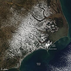
English: With miles of sandy beaches and generally good weather, coastal North Carolina isn’t a place you would usually expect to find snow. But the view from the Moderate Resolution Imaging Spectroradiometer (MODIS) on NASA’s Aqua satellite on February 14, 2010, shows snow extending to the Outer Banks. The sandy islands, normally pale tan, are bright white in this image. Harkers Island received 8.8 inches of snow, reported CNN. The snow fell in a winter storm that moved across the southern United States from Texas to the Atlantic Coast on February 12-13. |
| Tarix | |
| Çıme | http://earthobservatory.nasa.gov/NaturalHazards/view.php?id=42698&src=nha |
| Nuştekar | NASA |
| Versiyonane binan |
|

Lisans
| This file is in the public domain in the United States because it was solely created by NASA. NASA copyright policy states that "NASA material is not protected by copyright unless noted". (See Template:PD-USGov, NASA copyright policy page or JPL Image Use Policy.) | ||
 |
Warnings:
|
Verêniya dosya
Seba diyayışê viyarteyê dosya ra tarixê ke qısımê tarix/zemani derê inan bıtıkne.
| Tarix/Zeman | Resımo qıckek | Ebadi | Karber | Mışewre | |
|---|---|---|---|---|---|
| nıkayên | 19:42, 16 Şıbat 2010 | | 720 - 720 (455 KB) | Captain-tucker | {{Information |Description={{en|With miles of sandy beaches and generally good weather, coastal North Carolina isn’t a place you would usually expect to find snow. But the view from the Moderate Resolution Imaging Spectroradiometer (MODIS) on NASA’s A |
Gurenayışê dosya
The following pages link to this file:
Gurenayışê dosyaya gılovere
Ena dosya wikiyanê binan de gureniyena.
- ar.wikipedia.org sero guriyayış
- ary.wikipedia.org sero guriyayış
- arz.wikipedia.org sero guriyayış
- ast.wikipedia.org sero guriyayış
- ca.wikipedia.org sero guriyayış
- cy.wikipedia.org sero guriyayış
- dag.wikipedia.org sero guriyayış
- de.wikivoyage.org sero guriyayış
- eo.wikipedia.org sero guriyayış
- eu.wikipedia.org sero guriyayış
- fr.wikinews.org sero guriyayış
- fr.wikivoyage.org sero guriyayış
- ga.wikipedia.org sero guriyayış
- gl.wikipedia.org sero guriyayış
- ha.wikipedia.org sero guriyayış
- he.wikipedia.org sero guriyayış
- ht.wikipedia.org sero guriyayış
- hy.wikipedia.org sero guriyayış
- ia.wikipedia.org sero guriyayış
- ig.wikipedia.org sero guriyayış
- ku.wikipedia.org sero guriyayış
- mhr.wikipedia.org sero guriyayış
- nn.wikipedia.org sero guriyayış
- oc.wikipedia.org sero guriyayış
- os.wikipedia.org sero guriyayış
- pap.wikipedia.org sero guriyayış
- pl.wikipedia.org sero guriyayış
- ru.wikinews.org sero guriyayış
- sr.wikipedia.org sero guriyayış
- tg.wikipedia.org sero guriyayış
- tl.wikipedia.org sero guriyayış
- tt.wikipedia.org sero guriyayış
- vec.wikipedia.org sero guriyayış
- vi.wikipedia.org sero guriyayış
- www.wikidata.org sero guriyayış