Dosya:Topography Sri Lanka.jpg

Vervênayışê ebadê: 346 × 600 piksel. Agoznayışê bini: 138 × 240 piksel | 277 × 480 piksel | 443 × 768 piksel | 591 × 1,024 piksel | 1,181 × 2,048 piksel | 3,000 × 5,200 piksel.
Ebato oricinale (3,000 × 5,200 pikselan, ebatê dosya: 3.27 MB, MIME tipê cı: image/jpeg)
| Na dosya depoyê Wikimedia Commons de esta u terefê proceyanê binan ra gureniyena. Cêr dê şınasiya dosyay pela mocniyeno. |
Xulasa
| Şınasnayış |
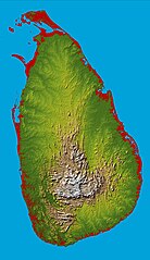
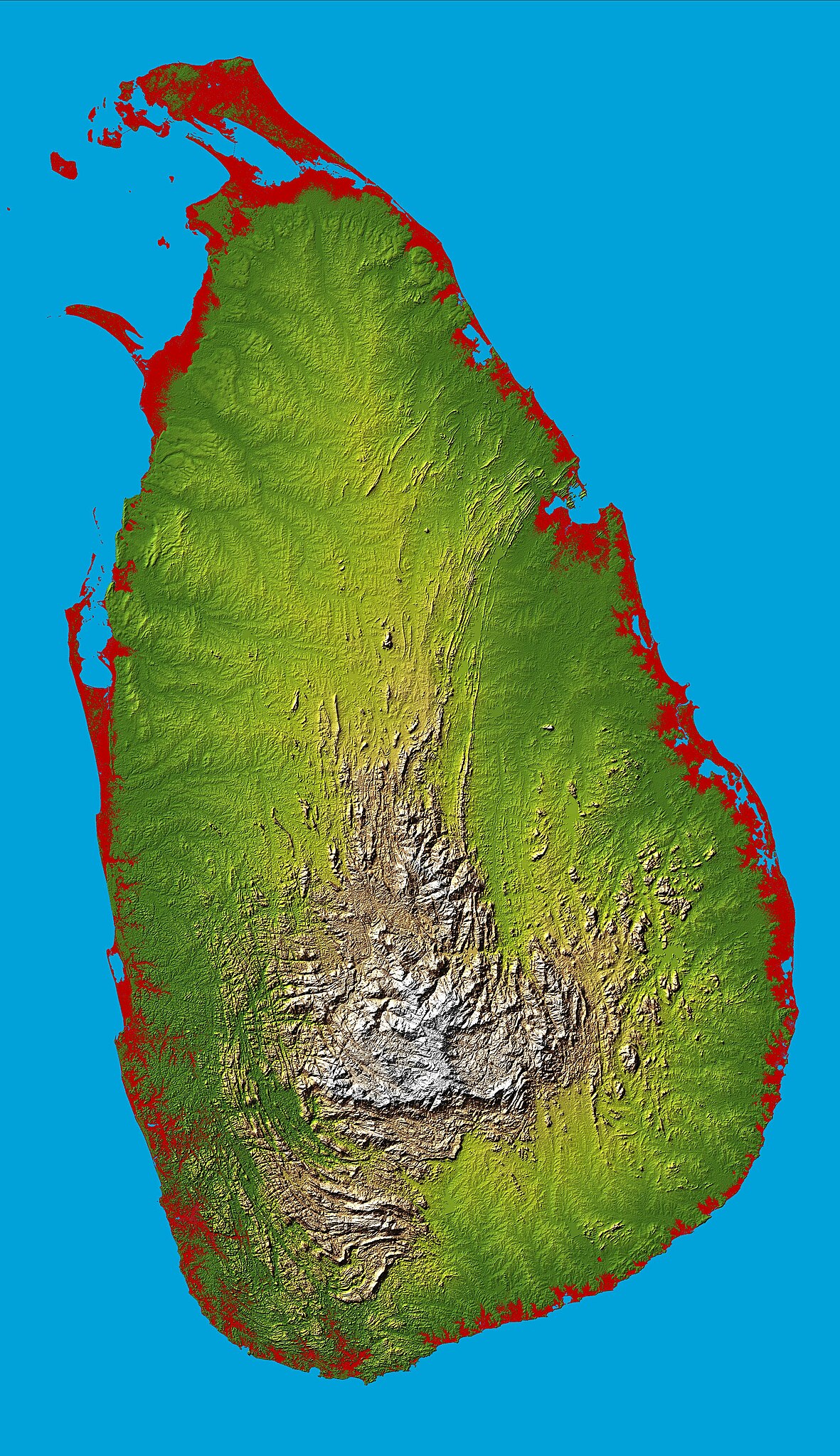
English: Topography of Sri Lanka, obtained from the Shuttle Radar Topography Mission of STS-99, aboard the Space Shuttle Endeavour. Heights below 10 meters (33 feet) above sea level have been colored red. |
| Tarix | |
| Çıme | http://photojournal.jpl.nasa.gov/catalog/PIA06670 |
| Nuştekar | National Aeronautics & Space Administration |
| Object location | | View this and other nearby images on: OpenStreetMap |
|---|
Lisans
| This file is in the public domain in the United States because it was solely created by NASA. NASA copyright policy states that "NASA material is not protected by copyright unless noted". (See Template:PD-USGov, NASA copyright policy page or JPL Image Use Policy.) | ||
 |
Warnings:
|
Verêniya dosya
Seba diyayışê viyarteyê dosya ra tarixê ke qısımê tarix/zemani derê inan bıtıkne.
| Tarix/Zeman | Resımo qıckek | Ebadi | Karber | Mışewre | |
|---|---|---|---|---|---|
| nıkayên | 17:43, 27 Adare 2005 | | 3,000 - 5,200 (3.27 MB) | FEXX | {{PD-USGov-NASA}} |
Gurenayışê dosya
The following pages link to this file:
Gurenayışê dosyaya gılovere
Ena dosya wikiyanê binan de gureniyena.
- af.wikipedia.org sero guriyayış
- ar.wikipedia.org sero guriyayış
- arz.wikipedia.org sero guriyayış
- ast.wikipedia.org sero guriyayış
- az.wikipedia.org sero guriyayış
- bcl.wikipedia.org sero guriyayış
- be.wikipedia.org sero guriyayış
- bg.wikipedia.org sero guriyayış
- bg.wiktionary.org sero guriyayış
- bn.wikipedia.org sero guriyayış
- ca.wikipedia.org sero guriyayış
- ceb.wikipedia.org sero guriyayış
- de.wikipedia.org sero guriyayış
- de.wikivoyage.org sero guriyayış
- el.wikipedia.org sero guriyayış
- en.wikipedia.org sero guriyayış
- Sri Lanka
- Geography of Sri Lanka
- Portal:Sri Lanka
- User:Trengarasu
- User:Deavenger
- Outline of Sri Lanka
- User:RitigalaJayasena/UserBoxes/EquitySriLanka
- User:ProudIrishAspie
- User:Djodjo666
- User:Blackknight12/sandbox
- User:DaisyGeekyTransGirl
- Wikipedia:Graphics Lab/Map workshop/Archive/Dec 2015
- User:JFoog
- User:Okiloma
- Wikipedia:Userboxes/Politics by country/Sri Lanka
- en.wikiversity.org sero guriyayış
- eo.wikipedia.org sero guriyayış
- es.wikipedia.org sero guriyayış
- et.wikipedia.org sero guriyayış
- fa.wikipedia.org sero guriyayış
- fi.wikipedia.org sero guriyayış
- fr.wikipedia.org sero guriyayış
Yê na dosya gurenayışê gıloveri tayêna bıvêne.