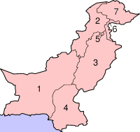
Eyaletê Pakıstani
Pakıstan de pêro piya 8 eyaleti estê û her eyalet de mıntıqeyê otonomiy estê.[1]

| Name | Statu | Erd(km²) | % | Nıfus(rec. 2011) | % | Merkez | |
|---|---|---|---|---|---|---|---|
| 1 | Beluçıstan | Province | 347,190 | 39 % | 13,162,222 | 7 % | Keta |
| 2 | Xeyber Pextunxwa | Province | 74,521 | 9 % | 26,896,829 | 14 % | Peşawer |
| 3 | Pencab | Province | 205,344 | 23 % | 91,379,615 | 46 % | Lahore |
| 4 | Sınd | Province | 140,914 | 16 % | 55,245,497 | 28 % | Karaçi |
| 5 | İslamabad | Territoire | 1,165 | 0,1 % | 1,151,868 | 0,6 % | İslamabad |
| 6 | FATA | Territoire | 27,220 | 3 % | 4,452,913 | 2,3 % | Peşawer |
| 7 | Keşmiro Azad | Territoire | 13,297 | 1,5 % | 3,631,224 | 1,8 % | Muzaferawan |
| 8 | Gilgit-Baltıstan | Territoire | 72,496 | 8 % | 1,441,523 | 0,7 % | Gilgit |
Eyaletê Pakıstani bıvurne
| Numre | Eyalet | Namê xoyo resmi | Paytext | Nıfus[2] | Erd(km²)[2] | Sıxletiye (inh. per km²) |
Xerita |
|---|---|---|---|---|---|---|---|
| 1 | Beluçıstan | بلوچستان | Keta | 4.8% | 39.3% | 18.9 | |
| 2 | Xeyber Pextunxwa | خیبرپختونخوا | Peşawer | 12.9% | 8.5% | 238.1 | |
| 3 | Pencab | پنجاب | Lahore | 53.7% | 23.3% | 358.5 | |
| 4 | Sınd | |سندھ | Karaçi | 22.2% | 16.0% | 216 | |
| 5 | İslamabad | وفاقی دارالحکومت | İslamabad | 0.6% | 0.1% | 888.8 | |
| 6 | FATA | وفاقی قبائلی علاقہ جات | Peşawer | 2.3% | 3.1% | 116.7 | |
| 7 | Keşmiro Azad | آزاد کشمیر | Muzaferawan | 2.2%[3] | 1.5%[3] | 223.6 | |
| 8 | Gilgit-Baltıstan | گلگت – بلتستان | Gilgit | 1.3% | 8.2% | 24.8 | |
| Pakıstan | پاکستان | İslamabad | 182,000,000 | 881,889 | 226.6/km2 |
Referansi bıvurne
- ↑ "Archive copy". Archived from the original on 2006-08-11. https://web.archive.org/web/20060811062602/http://www.mofa.gov.pk/Publications/constitution.pdf.
- ↑ 2.0 2.1 "Area, Population, Density and Urban/Rural Proportion by Administrative Units". Population Census Organization, Government of Pakistan. 1998. Archived from the original on 2005-01-05. https://web.archive.org/web/20050105015841/http://www.statpak.gov.pk/depts/pco/statistics/area_pop/area_pop.html. Retrieved 2010-03-31.
- ↑ 3.0 3.1 "Population features". Government of Azad Kashmir. 1998. Archived from the original on 2010-04-09. http://www.ajk.gov.pk/index.php?option=com_content&view=article&id=28&Itemid=11. Retrieved 2010-03-31.