Dosya:Abbasid Caliphate most extant.png
Deha berz agozney cı çıniyo
Abbasid_Caliphate_most_extant.png (800 × 487 pikselan, ebatê dosya: 85 KB, MIME tipê cı: image/png)
| Na dosya depoyê Wikimedia Commons de esta u terefê proceyanê binan ra gureniyena. Cêr dê şınasiya dosyay pela mocniyeno. |
| Şınasnayış |
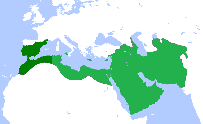
English: Locator map for the Abbasid Caliphate at its greatest extent, before the independence of al-Maghrib (Morocco and parts of Algeria) in 744 as well as al-Andalus (Spain and Portugal) 7yghfjs560the in the early 333 |
| Tarix | (UTC) |
| Çıme | |
| Nuştekar |
|
| no fotraf rotuşin biyo, fotrafi sero hebe ki vırnayış biyo. vırnayışi zi: seperated the parts that gained independance from the Abbasid Caliphate.orcinal fotrafo tiya de yo: Umayyad750ADloc.png. fotrafdı sazbiyayış zi Bassem kerdo.
|
Ez, ke ena dosya viraste, bine ena lisans ser cap kena:
Ena dosya binê Creative Commons Attribution 3.0 Unported lisans biya.
- Nê weçenegan dê xoseri:
- bare kerdene – qe gure kopya kerdişi, vila kerdişi u şawitişi
- qe reyna mix kerdişi – qe kabul kerdişi gure
- bine enê şarti:
- gıredayış – Lazımo ke şıma icazet bıdê, lisansi rê link, vuriyayış ke biyo belû kerê. Ney şıma usulên ra şenê bıkerê, labelê karkerdış u iştirakê şıma terefê wayirê lisansi ra zey qebulbiyene yew qeyde çıniyo.
Qeydê barkerdışê oricinali
This image is a derivative work of the following images:
- File:Umayyad750ADloc.png licensed with Cc-by-3.0
- 2009-04-22T16:17:51Z Gabagool 1481x902 (51495 Bytes) some corrections..
- 2009-04-20T16:10:54Z Gabagool 1481x902 (51573 Bytes) {{Information |Description={{en|1=Locator map for the Umayyad Caliphate at its greatest extent, c. AD 750. (Partially based on ''Atlas of World History'' (2007) - World 500-750, map.)}} |Source=Own work by uploader |Author=[
Uploaded with derivativeFX
Verêniya dosya
Seba diyayışê viyarteyê dosya ra tarixê ke qısımê tarix/zemani derê inan bıtıkne.
| Tarix/Zeman | Resımo qıckek | Ebadi | Karber | Mışewre | |
|---|---|---|---|---|---|
| nıkayên | 18:50, 13 Nisane 2013 | | 800 - 487 (85 KB) | Fry1989 | vandalism |
| 16:01, 13 Nisane 2013 |  | 800 - 487 (87 KB) | Mouh2jijel | Reverted to version as of 08:30, 13 April 2013 | |
| 14:32, 13 Nisane 2013 |  | 800 - 487 (85 KB) | Omar-toons | Reverted to version as of 23:40, 15 November 2012 rv unjustified revert | |
| 08:30, 13 Nisane 2013 |  | 800 - 487 (87 KB) | Mouh2jijel | Reverted to version as of 18:50, 8 April 2013 | |
| 06:18, 13 Nisane 2013 |  | 800 - 487 (85 KB) | Omar-toons | Reverted to version as of 23:40, 15 November 2012 unjustified revert | |
| 18:50, 8 Nisane 2013 |  | 800 - 487 (87 KB) | Mouh2jijel | Reverted to version as of 17:29, 24 April 2012 | |
| 23:40, 15 Tışrino Peyên 2012 |  | 800 - 487 (85 KB) | Omar-toons | moving southern Ifriqiyan limits a little bit to the north | |
| 17:29, 24 Nisane 2012 |  | 800 - 487 (87 KB) | Cplakidas | corrections: Sardinia and Corsica were never taken, and Sicily was not completely conquered until the 870s | |
| 19:11, 25 Nisane 2011 |  | 800 - 487 (87 KB) | باسم | added a few Mediterranean islands | |
| 18:12, 25 Nisane 2011 |  | 800 - 487 (87 KB) | باسم | {{Information |Description={{en|1=Locator map for the Abbasid Caliphate at its greatest extent, before the independence of al maghrib (morocco and parts of algeria) as well as al andalus (Spain and Portugal)}} |Source=*File:Umayyad750ADloc.png |Date |
Gurenayışê dosya
The following pages link to this file:
Gurenayışê dosyaya gılovere
Ena dosya wikiyanê binan de gureniyena.
- ar.wikipedia.org sero guriyayış
- العراق
- بغداد
- تاريخ العراق
- البصرة
- تاريخ إسلامي
- خلافة إسلامية
- الدولة العباسية
- غامد
- برامكة
- بوابة:الإسلام
- قائمة الخلفاء
- بوابة:الإسلام/مقالة مختارة
- تاريخ اليمن الإسلامي
- بوابة:الإمبراطورية الروسية
- بوابة:الإمبراطورية الروسية/بوابات شقيقة
- ويكيبيديا:مقالة الصفحة الرئيسية المختارة/152
- خالد بن برمك
- الممالك في إفريقيا قبل الاستعمار
- يحيى البرمكي
- بوابة:مكة/مقالة مختارة/أرشيف
- بوابة:مكة/مقالة مختارة/10
- بوابة:الأديان/تاريخ ديني
- بوابة:الإسلام/دولة مختارة
- بوابة:الإسلام/دولة مختارة/3
- بوابة:العراق/مقالة مختارة/أرشيف
- بوابة:العراق/مقالة مختارة/2
- بوابة:التاريخ الإسلامي/مقالة مختارة/أرشيف
- مستخدم:باحث
- بوابة:التاريخ/فقرات منوعة/3
- بوابة:التاريخ/فقرات منوعة/أرشيف
- بوابة:التاريخ الإسلامي/دولة مختارة/أرشيف
- بوابة:الإمبراطورية الألمانية
- بوابة:الإمبراطورية الألمانية/بوابات شقيقة
- بوابة:إمبراطورية اليابان
- بوابة:إمبراطورية اليابان/بوابات شقيقة
- بوابة:الخلافة الراشدة
- بوابة:الدولة الأموية
- ويكيبيديا:قائمة اليوم المختارة/يوليو 2015
- بوابة:التاريخ الإسلامي/دولة مختارة/4
- قالب:قائمة اليوم المختارة/2015-07-04
- بوابة:الإمبراطورية الفرنسية الأولى/بوابات شقيقة
- بوابة:الإمبراطورية الفرنسية الأولى
- بوابة:الإمبراطورية النمساوية/بوابات شقيقة
- بوابة:الإمبراطورية النمساوية
- بوابة:العالم الإسلامي
- قالب:مواضيع متعلقة 3
- قالب:مواضيع متعلقة 3/شرح
- بوابة:العالم الإسلامي/تاريخ
- بوابة:العالم الإسلامي/مواضيع متعلقة
- بوابة:الدولة العباسية/واجهة
Yê na dosya gurenayışê gıloveri tayêna bıvêne.