Dosya:Antarctica, Argentina territorial claim.svg

Ebadê verqaytê PNG na dosyay SVG: 600 × 600 piksel. Agoznayışê bini: 240 × 240 piksel | 480 × 480 piksel | 768 × 768 piksel | 1,024 × 1,024 piksel | 2,048 × 2,048 piksel | 806 × 806 piksel.
Ebato oricinale (Dosyay SVGi, nominal 806 × 806 pikseli, ebadê dosya: 65 KB)
| Na dosya depoyê Wikimedia Commons de esta u terefê proceyanê binan ra gureniyena. Cêr dê şınasiya dosyay pela mocniyeno. |
| Şınasnayış |
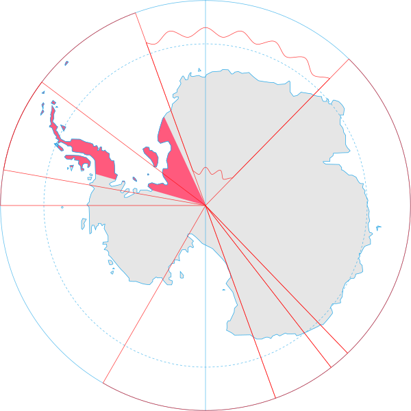
English: Map showing the territorial claim to Antarctica by the country in the filename. Also on the map are is the 60° S Parallel, Antarctic Circle, 0/180 latitude line and (in red) the borders of the claims by other states. |
| Tarix | |
| Çıme | Generated from Antarctica by Lokal_Profil. |
| Nuştekar | Lokal_Profil |
| Destur (Reyna sixulnayise ena dosya) |
Ena dosya binê Creative Commons Attribution-Share Alike 2.5 Generic lisans biya. Gırêdayış: Lokal_Profil
|
Verêniya dosya
Seba diyayışê viyarteyê dosya ra tarixê ke qısımê tarix/zemani derê inan bıtıkne.
| Tarix/Zeman | Resımo qıckek | Ebadi | Karber | Mışewre | |
|---|---|---|---|---|---|
| nıkayên | 20:55, 30 Hezirane 2008 | | 806 - 806 (65 KB) | Lokal Profil | {{Information |Description={{en|Map showing the territorial claim to Antarctica by the country in the filename. Also on the map are is the 60° S Parallel, Antarctic Circle, 0/180 latitude line and (in red) the borders of the claims by other states.}} |So |
Gurenayışê dosya
The following pages link to this file:
Gurenayışê dosyaya gılovere
Ena dosya wikiyanê binan de gureniyena.
- af.wikipedia.org sero guriyayış
- ar.wikipedia.org sero guriyayış
- ast.wikipedia.org sero guriyayış
- az.wikipedia.org sero guriyayış
- ca.wikipedia.org sero guriyayış
- chr.wikipedia.org sero guriyayış
- ckb.wikipedia.org sero guriyayış
- cs.wikipedia.org sero guriyayış
- da.wikipedia.org sero guriyayış
- de.wikipedia.org sero guriyayış
- el.wikipedia.org sero guriyayış
- en.wikipedia.org sero guriyayış
- eo.wikipedia.org sero guriyayış
- et.wikipedia.org sero guriyayış
- eu.wikipedia.org sero guriyayış
- fa.wikipedia.org sero guriyayış
- fi.wikipedia.org sero guriyayış
- frr.wikipedia.org sero guriyayış
- fr.wikipedia.org sero guriyayış
- gl.wikipedia.org sero guriyayış
- gv.wikipedia.org sero guriyayış
- hu.wikipedia.org sero guriyayış
- hy.wikipedia.org sero guriyayış
- id.wikipedia.org sero guriyayış
- ilo.wikipedia.org sero guriyayış
- it.wikipedia.org sero guriyayış
- ja.wikipedia.org sero guriyayış
Yê na dosya gurenayışê gıloveri tayêna bıvêne.