Dosya:Baikal-S1999276045323.png

Vervênayışê ebadê: 800 × 563 piksel. Agoznayışê bini: 320 × 225 piksel | 640 × 450 piksel | 1,024 × 720 piksel | 1,220 × 858 piksel.
Ebato oricinale (1,220 × 858 pikselan, ebatê dosya: 1.9 MB, MIME tipê cı: image/png)
| Na dosya depoyê Wikimedia Commons de esta u terefê proceyanê binan ra gureniyena. Cêr dê şınasiya dosyay pela mocniyeno. |
| Şınasnayış |
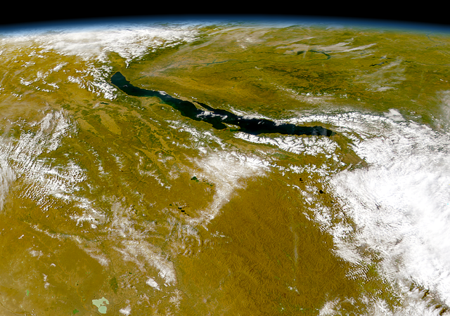
Čeština: Bajkal
|
||||
| Tarix | |||||
| Çıme | http://visibleearth.nasa.gov/view_rec.php?id=1002 - http://visibleearth.nasa.gov/images/1002/S1999276045323.png | ||||
| Nuştekar | Provided by the SeaWiFS Project, NASA/Goddard Space Flight Center, and ORBIMAGE | ||||
| Destur (Reyna sixulnayise ena dosya) |
|
Verêniya dosya
Seba diyayışê viyarteyê dosya ra tarixê ke qısımê tarix/zemani derê inan bıtıkne.
| Tarix/Zeman | Resımo qıckek | Ebadi | Karber | Mışewre | |
|---|---|---|---|---|---|
| nıkayên | 03:57, 21 Temuze 2005 | | 1,220 - 858 (1.9 MB) | Bdk | Lake Baikal *Source: http://visibleearth.nasa.gov/view_rec.php?id=1002 - http://visibleearth.nasa.gov/images/1002/S1999276045323.png *Sensor OrbView-2/SeaWiFS *Dates: Datastart 1999-10-03 - Visualization Date 1999-10-03 *Visible Earth v1 ID 3678 *Credit: |
Gurenayışê dosya
The following pages link to this file:
Gurenayışê dosyaya gılovere
Ena dosya wikiyanê binan de gureniyena.
- ar.wikipedia.org sero guriyayış
- arz.wikipedia.org sero guriyayış
- ast.wikipedia.org sero guriyayış
- as.wikipedia.org sero guriyayış
- az.wikipedia.org sero guriyayış
- be.wikipedia.org sero guriyayış
- ca.wikipedia.org sero guriyayış
- ce.wikipedia.org sero guriyayış
- crh.wikipedia.org sero guriyayış
- cs.wikipedia.org sero guriyayış
- cy.wikipedia.org sero guriyayış
- de.wikipedia.org sero guriyayış
- de.wikivoyage.org sero guriyayış
- de.wiktionary.org sero guriyayış
- el.wikipedia.org sero guriyayış
- en.wikipedia.org sero guriyayış
- eo.wikipedia.org sero guriyayış
- es.wikipedia.org sero guriyayış
- eu.wikipedia.org sero guriyayış
- fa.wikipedia.org sero guriyayış
- fr.wikivoyage.org sero guriyayış
- ga.wikipedia.org sero guriyayış
- he.wikipedia.org sero guriyayış
- hr.wikipedia.org sero guriyayış
- hu.wikipedia.org sero guriyayış
- hy.wikipedia.org sero guriyayış
- it.wikipedia.org sero guriyayış
- ja.wikipedia.org sero guriyayış
- ka.wikipedia.org sero guriyayış
- kbp.wikipedia.org sero guriyayış
- kk.wikipedia.org sero guriyayış
- lb.wikipedia.org sero guriyayış
- lmo.wikipedia.org sero guriyayış
- lv.wikipedia.org sero guriyayış
- mhr.wikipedia.org sero guriyayış
- mt.wikipedia.org sero guriyayış
- myv.wikipedia.org sero guriyayış
- my.wikipedia.org sero guriyayış
- mzn.wikipedia.org sero guriyayış
Yê na dosya gurenayışê gıloveri tayêna bıvêne.