Dosya:Climograma Santiago.png
Deha berz agozney cı çıniyo
Climograma_Santiago.png (450 × 450 pikselan, ebatê dosya: 11 KB, MIME tipê cı: image/png)
| Na dosya depoyê Wikimedia Commons de esta u terefê proceyanê binan ra gureniyena. Cêr dê şınasiya dosyay pela mocniyeno. |
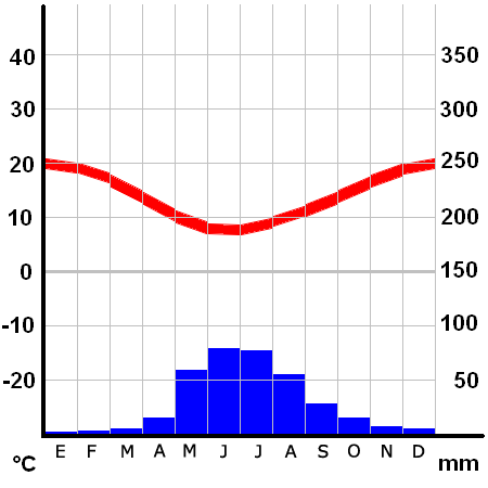
Xulasa
Climograma de Santiago de Chile (Pudahuel)
- Ubicación: 33º23' S 70º47' W
- Altura: 475 msnm
Lisans
Climograma basado en el realizado por Klimadiagramm archive copy at the Wayback Machine creado por Homeruniverse, cuyos archivos pertenecen al dominio público
Note: This tag is deprecated, please replace this template with {{PD-user-w}}
| |
Na karkerdış heta nuskar de Homeruniverse, at the German Wikipediya project ra biya malê şari deye hesereyaya. Dınya heme ca dı ravêrena. In case this is not legally possible: |
| Annotations | This image is annotated: View the annotations at Commons |
Verêniya dosya
Seba diyayışê viyarteyê dosya ra tarixê ke qısımê tarix/zemani derê inan bıtıkne.
| Tarix/Zeman | Resımo qıckek | Ebadi | Karber | Mışewre | |
|---|---|---|---|---|---|
| nıkayên | 04:26, 26 Çele 2006 | | 450 - 450 (11 KB) | B1mbo | Santiago Category:Santiago de Chile Climograma de Santiago de Chile (Pudahuel) *Ubicación: 33º23' S 70º47' W *Altura: 475 msnm ==Licensing== Climograma basado en el realizado por [http://homeruniverse.n� |
Gurenayışê dosya
The following pages link to this file:
Gurenayışê dosyaya gılovere
Ena dosya wikiyanê binan de gureniyena.
- ca.wikipedia.org sero guriyayış
- crh.wikipedia.org sero guriyayış
- es.wikipedia.org sero guriyayış
- es.wikivoyage.org sero guriyayış
- fi.wikipedia.org sero guriyayış
- fr.wikipedia.org sero guriyayış
- gl.wikipedia.org sero guriyayış
- hu.wikipedia.org sero guriyayış
- id.wikipedia.org sero guriyayış
- ja.wikibooks.org sero guriyayış
- pl.wikipedia.org sero guriyayış
- pt.wikipedia.org sero guriyayış
- sq.wikipedia.org sero guriyayış
- zh-classical.wikipedia.org sero guriyayış
- zh.wikipedia.org sero guriyayış