Dosya:First.Crusade.Map.jpg
Ebato oricinale (1,730 × 1,402 pikselan, ebatê dosya: 730 KB, MIME tipê cı: image/jpeg)
| Na dosya depoyê Wikimedia Commons de esta u terefê proceyanê binan ra gureniyena. Cêr dê şınasiya dosyay pela mocniyeno. |
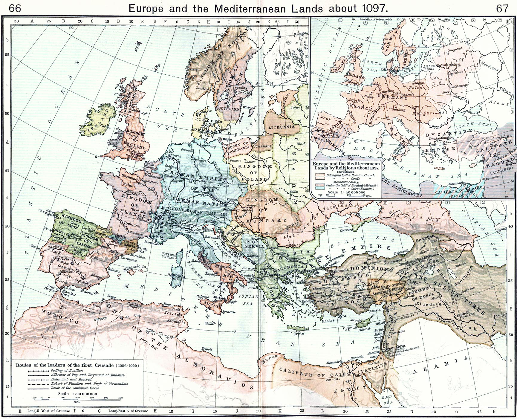
"Route of the leaders of the first crusade." By William Shepherd, Historical Atlas, 1911.
Source: en:Image:First.Crusade.Map.jpg <- http://www.lib.utexas.edu/maps/historical/history_shepherd_1911.html
Uploaded by: en:User:Stbalbach
_en.png)
.png)
.jpg)
|
Na gurweynayış DAY dı yana nuskare cı merdışi sera 70 yana dehana veşi zeman reverdo se dewleta piron dı beno Male şariyo.
| |
| Na dosya u eleqyın heqê bini heq dê telifiye bındı karkerdışê cı pêro zi miyan hesıbyayê u xoseri lisans deye nışaniyayê. | |
| Annotations | This image is annotated: View the annotations at Commons |
Verêniya dosya
Seba diyayışê viyarteyê dosya ra tarixê ke qısımê tarix/zemani derê inan bıtıkne.
| Tarix/Zeman | Resımo qıckek | Ebadi | Karber | Mışewre | |
|---|---|---|---|---|---|
| nıkayên | 14:53, 6 Kanun 2014 | | 1,730 - 1,402 (730 KB) | Hohum | Reworked, closer to original colours |
| 15:01, 2 Kanun 2010 |  | 1,730 - 1,385 (1.21 MB) | P. S. Burton | cropped | |
| 16:32, 28 Nisane 2009 |  | 1,938 - 1,542 (718 KB) | Alex:D | whitened | |
| 13:57, 8 Adare 2005 |  | 1,938 - 1,542 (712 KB) | Nk | "Route of the leaders of the first crusade." By William Shepherd, Historical Atlas, 1911. {{PD}} |
Gurenayışê dosya
The following pages link to this file:
Gurenayışê dosyaya gılovere
Ena dosya wikiyanê binan de gureniyena.
- af.wikipedia.org sero guriyayış
- an.wikipedia.org sero guriyayış
- ar.wikipedia.org sero guriyayış
- azb.wikipedia.org sero guriyayış
- be-tarask.wikipedia.org sero guriyayış
- be.wikipedia.org sero guriyayış
- bg.wikipedia.org sero guriyayış
- bi.wikipedia.org sero guriyayış
- bm.wikipedia.org sero guriyayış
- bn.wikipedia.org sero guriyayış
- br.wikipedia.org sero guriyayış
- ca.wikipedia.org sero guriyayış
- cbk-zam.wikipedia.org sero guriyayış
- co.wikipedia.org sero guriyayış
- csb.wikipedia.org sero guriyayış
- cs.wikipedia.org sero guriyayış
- cy.wikipedia.org sero guriyayış
- da.wikipedia.org sero guriyayış
- de.wikipedia.org sero guriyayış
- 1097
- Benutzer:Angelika Lindner
- Benutzer:Heimatforscher
- Benutzer:Pez
- Benutzer:Carbenium
- Benutzer:Christoph73
- Benutzer:Thelastping
- Benutzer:-RF-
- Benutzer:Metrics
- Benutzer:Alex mueller
- Benutzer:J. Patrick Fischer
- Benutzer:Smog17
- Benutzer:Sarkana/Archiv
- Benutzer:Maxx82
- Benutzer:DocTrax
- Benutzer:Apfel3748
- Benutzer:Doominator
- Benutzer:Salzburger
- Benutzer:AnKaiLong
- Benutzer:Ephraim33/Vorlagen
- Benutzer:Raubfisch/Vorlagen
- Benutzer:Raubfisch/Vorlage:aus dem alten Europa
- Benutzer:BigAl
- Benutzer:Net-breuer
- Benutzer:Sir.toby
- Benutzer:RayBan
Yê na dosya gurenayışê gıloveri tayêna bıvêne.