Dosya:Hundred years war.gif

Vervênayışê ebadê: 522 × 599 piksel. Agoznayışê bini: 209 × 240 piksel | 541 × 621 piksel.
Ebato oricinale (541 × 621 pikselan, ebatê dosya: 140 KB, MIME tipê cı: image/gif, viyariye biyo, 10 çerçeveyi, 35 san)
| Na dosya depoyê Wikimedia Commons de esta u terefê proceyanê binan ra gureniyena. Cêr dê şınasiya dosyay pela mocniyeno. |
Xulasa
| Şınasnayış |
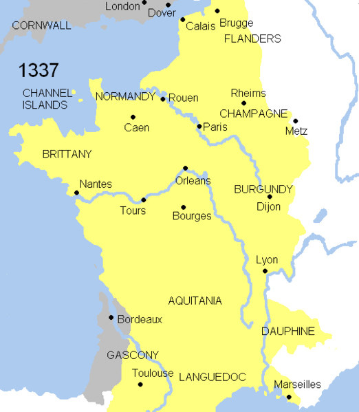
English: Animated map Hundred years war. This map shows the war`s evolution and the most important battles.
Displayed in the map: France
England
Burgundy
Battles-Battle of Crecy (1346), Battle of Poitiers (1356), Battle of Agincourt (1415), Battle of Castillon (1429), Battle of Formigny (1450)
Years shown: 1337, 1346, 1356, 1360, 1415, 1429, 1429-31, 1450, 1451-53, 1453. |
| Tarix | |
| Çıme | |
| Nuştekar | Andrein (d) |
Lisans
| Na karkerdış heta nuskar de Andrein ra biya malê şari deye hesereyaya. Dınya heme ca dı ravêrena. Tay dewletan dı no kanuniyey heta mıkum nêbone; o haldı: |

|
This map has been uploaded by Electionworld from en.wikipedia.org to enable the |
Verêniya dosya
Seba diyayışê viyarteyê dosya ra tarixê ke qısımê tarix/zemani derê inan bıtıkne.
| Tarix/Zeman | Resımo qıckek | Ebadi | Karber | Mışewre | |
|---|---|---|---|---|---|
| nıkayên | 08:37, 21 Temuze 2008 | | 541 - 621 (140 KB) | Chphe | without watermark |
| 12:23, 17 Adare 2007 |  | 541 - 621 (139 KB) | Electionworld | == Licensing == {{PD-self}} {{ew|en|Andrei Nacu}} Category:Maps of the history of France == File History in Wikipedia== Legend: (cur) = this is the current file, (del) = delete this old version, (rev) = revert to this old version. Click on date to do |
Gurenayışê dosya
The following pages link to this file:
Gurenayışê dosyaya gılovere
Ena dosya wikiyanê binan de gureniyena.
- am.wikipedia.org sero guriyayış
- azb.wikipedia.org sero guriyayış
- az.wikipedia.org sero guriyayış
- ba.wikipedia.org sero guriyayış
- be.wikipedia.org sero guriyayış
- bg.wikipedia.org sero guriyayış
- ca.wikipedia.org sero guriyayış
- crh.wikipedia.org sero guriyayış
- cs.wikipedia.org sero guriyayış
- cy.wikipedia.org sero guriyayış
- en.wikipedia.org sero guriyayış
- en.wikibooks.org sero guriyayış
- eo.wikipedia.org sero guriyayış
- es.wikipedia.org sero guriyayış
- et.wikipedia.org sero guriyayış
- fa.wikipedia.org sero guriyayış
- fr.wikipedia.org sero guriyayış
- ga.wikipedia.org sero guriyayış
- he.wikipedia.org sero guriyayış
- hif.wikipedia.org sero guriyayış
- hu.wikipedia.org sero guriyayış
- id.wikibooks.org sero guriyayış
- is.wikipedia.org sero guriyayış
- it.wikipedia.org sero guriyayış
- ja.wikipedia.org sero guriyayış
- ka.wikipedia.org sero guriyayış
- ko.wikipedia.org sero guriyayış
Yê na dosya gurenayışê gıloveri tayêna bıvêne.