Dosya:Jakarta Skyline Part 2.jpg

Ebato oricinale (1,546 × 768 pikselan, ebatê dosya: 801 KB, MIME tipê cı: image/jpeg)
| Na dosya depoyê Wikimedia Commons de esta u terefê proceyanê binan ra gureniyena. Cêr dê şınasiya dosyay pela mocniyeno. |

|
Copyright warning: A subject in this image is protected by copyright.
This image features an architectural or artistic work, photographed from a public space in Indonesia. There are no freedom of panorama exceptions of any kind under the Chapter VI (Copyright Limitations), Articles 43–51 of the Indonesian Copyright Act No. 28, 2014, which means that these architectural or artistic works cannot be photographed freely for anything other than non-commercial or personal uses. If a copyrighted architectural or artistic work is contained in this image and it is a substantial reproduction, this photo cannot be licensed under a free license, and will be deleted. Framing this image to focus on the copyrighted work is also a copyright violation. Before reusing this content, ensure that you have the right to do so. You are solely responsible for ensuring that you do not infringe someone else's copyrights. See our general disclaimer for more information. |

Xulasa
| Şınasnayış |
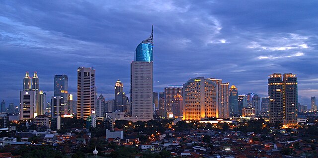
English: Lining up Jakarta's skyscrapers along the CBD with Wisma 46 as the centerpiece.
Wisma 46 is designed by Zeidler Partnership and has been well-known for being Indonesia's tallest building; and Jakarta's most distinguished skyscrapers with its unique shape resembling an elegant fountain pen. Singapore may have a "Durian" (The Esplanade); and Beijing has a "Bird's Nest" (Olympic Stadium) and "Trousers Pants" (CCTV Tower); but Jakarta has an elegant "Fountain Pen". Although it may not be the tallest building in Indonesia now, -with the completion of Menara BCA and The Kempinski Residences at the Grand Indonesia Mall complex; and construction at The Jakarta Tower (558m) is coming soon-, Wisma 46 remains one of the nation's most distinguished and unique building. |
| Tarix | |
| Çıme | https://www.flickr.com/photos/joe-joe/2303992129/ |
| Nuştekar | yohanes budiyanto |
| Object location | | View this and other nearby images on: OpenStreetMap |
|---|
Lisans
- Nê weçenegan dê xoseri:
- bare kerdene – qe gure kopya kerdişi, vila kerdişi u şawitişi
- qe reyna mix kerdişi – qe kabul kerdişi gure
- bine enê şarti:
- gıredayış – Lazımo ke şıma icazet bıdê, lisansi rê link, vuriyayış ke biyo belû kerê. Ney şıma usulên ra şenê bıkerê, labelê karkerdış u iştirakê şıma terefê wayirê lisansi ra zey qebulbiyene yew qeyde çıniyo.
| This image was originally posted to Flickr by yohanes budiyanto at https://www.flickr.com/photos/27228523@N00/2303992129. It was reviewed on 20 Kanun 2009 by FlickreviewR and was confirmed to be licensed under the terms of the cc-by-2.0. |
Verêniya dosya
Seba diyayışê viyarteyê dosya ra tarixê ke qısımê tarix/zemani derê inan bıtıkne.
| Tarix/Zeman | Resımo qıckek | Ebadi | Karber | Mışewre | |
|---|---|---|---|---|---|
| nıkayên | 21:45, 3 Gulane 2023 | | 1,546 - 768 (801 KB) | B18IDH | Maybe This Is More Correct? |
| 19:05, 19 Kanun 2009 |  | 906 - 450 (519 KB) | Rochelimit | {{Information |Description={{en|1=Lining up Jakarta's skyscrapers. I took similar picture before with my Leica. This time, I tried it with my E-500 when the setting is blue, unlike previously in magenta. I'm also trying the 'golden rule' where the most pr |
Gurenayışê dosya
The following pages link to this file:
Gurenayışê dosyaya gılovere
Ena dosya wikiyanê binan de gureniyena.
- ar.wikipedia.org sero guriyayış
- arz.wikipedia.org sero guriyayış
- ast.wikipedia.org sero guriyayış
- azb.wikipedia.org sero guriyayış
- ban.wikipedia.org sero guriyayış
- ba.wikipedia.org sero guriyayış
- bjn.wikipedia.org sero guriyayış
- blk.wikipedia.org sero guriyayış
- bn.wikipedia.org sero guriyayış
- bn.wikibooks.org sero guriyayış
- bs.wikipedia.org sero guriyayış
- bug.wikipedia.org sero guriyayış
- bxr.wikipedia.org sero guriyayış
- ceb.wikipedia.org sero guriyayış
- ckb.wikipedia.org sero guriyayış
- crh.wikipedia.org sero guriyayış
- csb.wikipedia.org sero guriyayış
- cu.wikipedia.org sero guriyayış
- cy.wikipedia.org sero guriyayış
- dag.wikipedia.org sero guriyayış
- de.wikipedia.org sero guriyayış
- dv.wikipedia.org sero guriyayış
- en.wikipedia.org sero guriyayış
- en.wikivoyage.org sero guriyayış
- eo.wikipedia.org sero guriyayış
- es.wikipedia.org sero guriyayış
- eu.wikipedia.org sero guriyayış
- fa.wikipedia.org sero guriyayış
- fi.wikipedia.org sero guriyayış
Yê na dosya gurenayışê gıloveri tayêna bıvêne.