Dosya:Kalmykia03.png

Vervênayışê ebadê: 680 × 600 piksel. Agoznayışê bini: 272 × 240 piksel | 544 × 480 piksel | 738 × 651 piksel.
Ebato oricinale (738 × 651 pikselan, ebatê dosya: 44 KB, MIME tipê cı: image/png)
| Na dosya depoyê Wikimedia Commons de esta u terefê proceyanê binan ra gureniyena. Cêr dê şınasiya dosyay pela mocniyeno. |
Xulasa
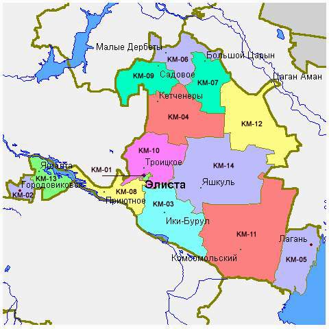
- Map of the Republic of Kalmykia.
Source and license

|
This map has been uploaded by Electionworld from en.wikipedia.org to enable the |
Map made by PANONIAN
| Na karkerdış heta nuskar de PANONIAN ra biya malê şari deye hesereyaya. Dınya heme ca dı ravêrena. Tay dewletan dı no kanuniyey heta mıkum nêbone; o haldı: |
References
Maps of Kalmykia:
- http://www.mapzones.com/citymap/russia/republic_of_kalmykia/republic_of_kalmykia.jpg
- http://www.eatingahobo.com/kalmykia01.gif
- https://www.usrbc.org/pics/Image/Russian%20Regions/Kalmykia%20Republic/map_kalmyk.gif
- http://www.zum.de/whkmla/histatlas/russia/kalmykia.gif
- http://www.rdaward.org/map/6i.jpg
- http://farm4.static.flickr.com/3050/3255735175_fd4c1a7b79.jpg
- http://files.vector-images.com/clipart/kalmykia_map.gif
- http://farm3.staticflickr.com/2358/2163150592_33a3152774.jpg
- http://www.regions.newsall.ru/kalmykia/kalmykia.htm.gif
- http://www.tatneft.ru/wps/wcm/jsp/getImage.jsp?content_id=com.ibm.workplace.wcm.api.WCM_Content/news_2009.05.12_16.18.03.669/db640a804e13769483b6b7f586c5a29c/PUBLISHED&name=image
Largest settlements in Kalmykia:
Verêniya dosya
Seba diyayışê viyarteyê dosya ra tarixê ke qısımê tarix/zemani derê inan bıtıkne.
| Tarix/Zeman | Resımo qıckek | Ebadi | Karber | Mışewre | |
|---|---|---|---|---|---|
| nıkayên | 10:48, 14 Gulane 2012 | | 738 - 651 (44 KB) | PANONIAN | Reverted to version as of 09:07, 14 May 2012 - trying to fix thumbnail problem once more |
| 09:18, 14 Gulane 2012 |  | 738 - 651 (44 KB) | PANONIAN | Reverted to version as of 09:07, 14 May 2012 - thumbnail problem | |
| 09:17, 14 Gulane 2012 |  | 571 - 487 (14 KB) | PANONIAN | Reverted to version as of 16:09, 29 December 2006 - thumbnail problem | |
| 09:07, 14 Gulane 2012 |  | 738 - 651 (44 KB) | PANONIAN | improved version | |
| 16:09, 29 Kanun 2006 |  | 571 - 487 (14 KB) | Electionworld | {{ew|en|PANONIAN}} Map made by PANONIAN {{PD-user|PANONIAN}} Category:Maps of the Russian republics |
Gurenayışê dosya
The following pages link to this file:
Gurenayışê dosyaya gılovere
Ena dosya wikiyanê binan de gureniyena.
- ace.wikipedia.org sero guriyayış
- an.wikipedia.org sero guriyayış
- ast.wikipedia.org sero guriyayış
- bg.wikipedia.org sero guriyayış
- bn.wikipedia.org sero guriyayış
- bs.wikipedia.org sero guriyayış
- bxr.wikipedia.org sero guriyayış
- cs.wikipedia.org sero guriyayış
- cv.wikipedia.org sero guriyayış
- cy.wikipedia.org sero guriyayış
- da.wikipedia.org sero guriyayış
- de.wikipedia.org sero guriyayış
- en.wikipedia.org sero guriyayış
- eo.wikipedia.org sero guriyayış
- es.wikipedia.org sero guriyayış
- et.wikipedia.org sero guriyayış
- fa.wikipedia.org sero guriyayış
- fi.wikipedia.org sero guriyayış
- fr.wikipedia.org sero guriyayış
- gag.wikipedia.org sero guriyayış
- ga.wikipedia.org sero guriyayış
- hi.wikipedia.org sero guriyayış
- hr.wikipedia.org sero guriyayış
- hu.wikipedia.org sero guriyayış
- id.wikipedia.org sero guriyayış
- incubator.wikimedia.org sero guriyayış
- it.wikipedia.org sero guriyayış
- ja.wikipedia.org sero guriyayış
- ka.wikipedia.org sero guriyayış
- kbd.wikipedia.org sero guriyayış
- ko.wikipedia.org sero guriyayış
- kv.wikipedia.org sero guriyayış
- la.wikipedia.org sero guriyayış
- mk.wikipedia.org sero guriyayış
- mn.wikipedia.org sero guriyayış
- mr.wikipedia.org sero guriyayış
- ms.wikipedia.org sero guriyayış
- myv.wikipedia.org sero guriyayış
- nl.wikipedia.org sero guriyayış
- nn.wikipedia.org sero guriyayış
- no.wikipedia.org sero guriyayış
- pl.wikipedia.org sero guriyayış
Yê na dosya gurenayışê gıloveri tayêna bıvêne.