Dosya:L'île de la Réunion vue par le satellite Sentinel-2 (cropped).jpg

Ebato oricinale (5,000 × 4,232 pikselan, ebatê dosya: 18.68 MB, MIME tipê cı: image/jpeg)
| Na dosya depoyê Wikimedia Commons de esta u terefê proceyanê binan ra gureniyena. Cêr dê şınasiya dosyay pela mocniyeno. |
Xulasa
| Şınasnayış |
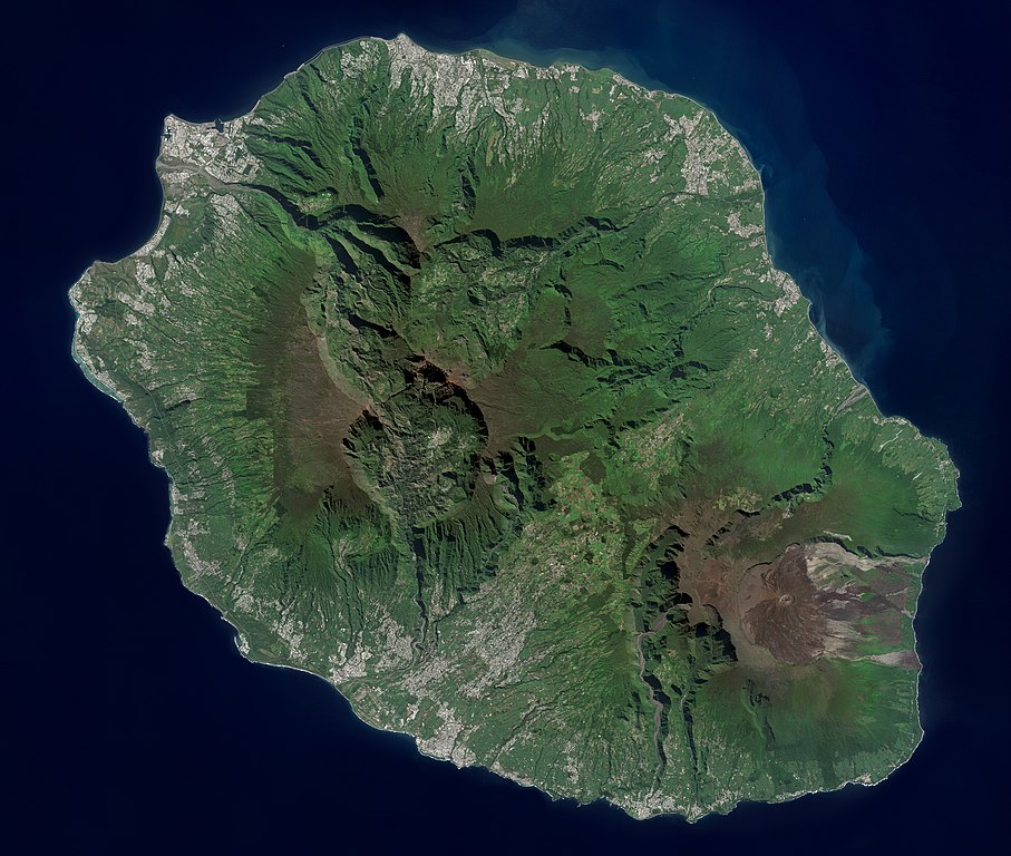
Français : L'île de la Réunion vue par le satellite Sentinel-2
English: Réunion island (Indian Ocean) photographed by Sentinel-2 satellite. |
| Tarix | |
| Çıme | https://phototheque.cnes.fr/cnes/media/68926 |
| Nuştekar | European Space Agency / CNES |
| Versiyonane binan |

.jpg)
| Camera location | | View this and other nearby images on: OpenStreetMap |
|---|
.jpg¶ms=-21.134472_N_0055.247103_E_globe:Earth_type:camera__&language=diq)
Lisans

|
This image contains data from a satellite in the Copernicus Programme, such as Sentinel-1, Sentinel-2 or Sentinel-3. Attribution is required when using this image.
Gırêdayış: Contains modified Copernicus Sentinel data 2021
The use of Copernicus Sentinel Data is regulated under EU law (Commission Delegated Regulation (EU) No 1159/2013 and Regulation (EU) No 377/2014). Relevant excerpts:
Free access shall be given to GMES dedicated data [...] made available through GMES dissemination platforms [...].
Access to GMES dedicated data [...] shall be given for the purpose of the following use in so far as it is lawful:
GMES dedicated data [...] may be used worldwide without limitations in time.
GMES dedicated data and GMES service information are provided to users without any express or implied warranty, including as regards quality and suitability for any purpose. |

|
This image has been assessed under the valued image criteria and is considered the most valued image on Commons within the scope: Réunion island, France - satellite view.. You can see its nomination here. |
.jpg)
Verêniya dosya
Seba diyayışê viyarteyê dosya ra tarixê ke qısımê tarix/zemani derê inan bıtıkne.
| Tarix/Zeman | Resımo qıckek | Ebadi | Karber | Mışewre | |
|---|---|---|---|---|---|
| nıkayên | 14:12, 6 Keşkelun 2022 | | 5,000 - 4,232 (18.68 MB) | Skimel | File:L'île de la Réunion vue par le satellite Sentinel-2.jpg cropped 15 % vertically using CropTool with precise mode. |
Gurenayışê dosya
The following pages link to this file:
Gurenayışê dosyaya gılovere
Ena dosya wikiyanê binan de gureniyena.
- ar.wikipedia.org sero guriyayış
- arz.wikipedia.org sero guriyayış
- ast.wikipedia.org sero guriyayış
- az.wikipedia.org sero guriyayış
- ca.wikipedia.org sero guriyayış
- ce.wikipedia.org sero guriyayış
- cy.wikipedia.org sero guriyayış
- es.wikipedia.org sero guriyayış
- es.wikivoyage.org sero guriyayış
- fr.wikinews.org sero guriyayış
- fr.wikivoyage.org sero guriyayış
- ga.wikipedia.org sero guriyayış
- gl.wikipedia.org sero guriyayış
- ht.wikipedia.org sero guriyayış
- hy.wikipedia.org sero guriyayış
- ia.wikipedia.org sero guriyayış
- ig.wikipedia.org sero guriyayış
- ku.wikipedia.org sero guriyayış
- no.wikipedia.org sero guriyayış
- oc.wikipedia.org sero guriyayış
- pl.wikipedia.org sero guriyayış
- ps.wikipedia.org sero guriyayış
- tl.wikipedia.org sero guriyayış
- vec.wikipedia.org sero guriyayış
- vi.wikipedia.org sero guriyayış
- www.wikidata.org sero guriyayış
.jpg)