Dosya:Map of Utah highlighting Utah County.svg

Ebadê verqaytê PNG na dosyay SVG: 480 × 599 piksel. Agoznayışê bini: 192 × 240 piksel | 384 × 480 piksel | 615 × 768 piksel | 820 × 1,024 piksel | 1,640 × 2,048 piksel | 4,457 × 5,566 piksel.
Ebato oricinale (Dosyay SVGi, nominal 4,457 × 5,566 pikseli, ebadê dosya: 50 KB)
| Na dosya depoyê Wikimedia Commons de esta u terefê proceyanê binan ra gureniyena. Cêr dê şınasiya dosyay pela mocniyeno. |
Xulasa
| Şınasnayış |
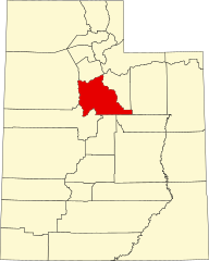
English: This is a locator map showing Utah County in Utah. For more information, see Commons:United States county locator maps. |
| Tarix | |
| Çıme |
Karo şexsi: English: The maps use data from nationalatlas.gov, specifically countyp020.tar.gz on the Raw Data Download page. The maps also use state outline data from statesp020.tar.gz. The Florida maps use hydrogm020.tar.gz to display Lake Okeechobee. |
| Nuştekar | David Benbennick |
| SVG genesis | This W3C-invalid locator map was created with unknown tool. |
Lisans
| Ez, Wêrê ena teliferê, nê kari Malê şarideye ezo heserena. Dınya heme ca dı ravêreno. Tay dewletan dı no kanuniyey heta mıkum nêbone; o haldı: Ez, ena karer qande herhangi yew amaci, be şert, hendı ke legali icab nikeni, şari hemi re ezo mısade dana. |
Verêniya dosya
Seba diyayışê viyarteyê dosya ra tarixê ke qısımê tarix/zemani derê inan bıtıkne.
| Tarix/Zeman | Resımo qıckek | Ebadi | Karber | Mışewre | |
|---|---|---|---|---|---|
| nıkayên | 05:04, 24 Tışrino Peyên 2020 | | 4,457 - 5,566 (50 KB) | 4nn1l2 | Special:diff/514604312 |
| 17:36, 12 Şıbat 2006 |  | 4,457 - 5,566 (56 KB) | David Benbennick | {{subst:User:Dbenbenn/clm|county=Utah County|state=Utah|type=county}} |
Gurenayışê dosya
The following pages link to this file:
Gurenayışê dosyaya gılovere
Ena dosya wikiyanê binan de gureniyena.
- ar.wikipedia.org sero guriyayış
- مقاطعة يوتا (يوتا)
- بروفو
- ثيستل (يوتا)
- سيدار فورت (يوتا)
- فيرفيلد (يوتا)
- غينولا (يوتا)
- غوشن (يوتا)
- فينيارد (يوتا)
- أوريم (يوتا)
- سبرينغفيل (يوتا)
- أمريكان فورك
- بايسون
- سبانيش فورك
- ألباين
- ليهي
- بليزانت غروف
- درابر
- سانتاكوين
- سيدار هيلز
- هايلاند (يوتا)
- ليندون (يوتا)
- مابلتون (يوتا)
- سالم (يوتا)
- إلك ريدج
- وودلاند هيلز (يوتا)
- بلوفديل
- ساراتوغا سبرينغز
- إيغل ماونتن
- قائمة مقاطعات يوتا
- سبرينغ لاك (يوتا)
- ويست ماونتين (يوتا)
- بنجامين (يوتا)
- قالب:مقاطعة يوتا (يوتا)
- إلبرتا (يوتا)
- لاك شور (يوتا)
- be.wikipedia.org sero guriyayış
- bg.wikipedia.org sero guriyayış
- bpy.wikipedia.org sero guriyayış
- cdo.wikipedia.org sero guriyayış
- ceb.wikipedia.org sero guriyayış
- ce.wikipedia.org sero guriyayış
- cs.wikipedia.org sero guriyayış
- cy.wikipedia.org sero guriyayış
- de.wikipedia.org sero guriyayış
Yê na dosya gurenayışê gıloveri tayêna bıvêne.