Dosya:Map of the Philippines Demis.png

Vervênayışê ebadê: 397 × 599 piksel. Agoznayışê bini: 159 × 240 piksel | 318 × 480 piksel | 814 × 1,228 piksel.
Ebato oricinale (814 × 1,228 pikselan, ebatê dosya: 299 KB, MIME tipê cı: image/png)
| Na dosya depoyê Wikimedia Commons de esta u terefê proceyanê binan ra gureniyena. Cêr dê şınasiya dosyay pela mocniyeno. |
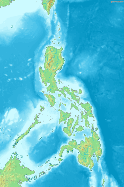
Map of the Philippines
Bounding box West 115.5°, South 3.7°, East 129°, North 23.5°. Center at 13°36′00″N 122°15′00″E / 13.60000°N 122.25000°E.
This image is in the public domain because it came from the site https://www.demis.nl/products/web-map-server/examples/ and was released by the copyright holder. Permission is granted to copy, distribute and/or modify this map since it is based on free of copyright images from: www.demis.nl. See also approval email on de.wp and its clarification.
|
| This work has been released into the public domain by its copyright holder, www.demis.nl. This applies worldwide. Tay dewletan dı no kanuniyey heta mıkum nêbone; o haldı: Ez, ena www.demis.nl qande herhangi yew amaci, be şert, hendı ke legali icab nikeni, şari hemi re ezo mısade dana.
|
Verêniya dosya
Seba diyayışê viyarteyê dosya ra tarixê ke qısımê tarix/zemani derê inan bıtıkne.
| Tarix/Zeman | Resımo qıckek | Ebadi | Karber | Mışewre | |
|---|---|---|---|---|---|
| nıkayên | 18:04, 20 Kanun 2006 | | 814 - 1,228 (299 KB) | Mats Halldin~commonswiki | Map of the Philippines Bounding box West 115.5°, South 3.7°, East 129°, North 23.5°. Center at {{coor d|13.60000|N|122.25000|E|scale:11880000}}. {{demis-pd}} Category:Maps of the Philippines |
Gurenayışê dosya
The following pages link to this file:
Gurenayışê dosyaya gılovere
Ena dosya wikiyanê binan de gureniyena.
- en.wikipedia.org sero guriyayış
- eo.wikipedia.org sero guriyayış
- es.wikipedia.org sero guriyayış
- la.wikipedia.org sero guriyayış
- mg.wikipedia.org sero guriyayış
- sq.wikipedia.org sero guriyayış
- sv.wikipedia.org sero guriyayış
- uk.wikipedia.org sero guriyayış