Dosya:MoldRelief.jpg

Vervênayışê ebadê: 484 × 599 piksel. Agoznayışê bini: 194 × 240 piksel | 388 × 480 piksel | 620 × 768 piksel | 827 × 1,024 piksel | 1,727 × 2,138 piksel.
Ebato oricinale (1,727 × 2,138 pikselan, ebatê dosya: 493 KB, MIME tipê cı: image/jpeg)
| Na dosya depoyê Wikimedia Commons de esta u terefê proceyanê binan ra gureniyena. Cêr dê şınasiya dosyay pela mocniyeno. |
Xulasa
| Şınasnayış |
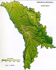
English: Physical map of Moldova
Français : Relief de la République de Moldavie |
|||||
| Tarix | ||||||
| Çıme | Background: NASA - drawing generated since data from NASA Johnson Space Center - Earth Sciences and Image Analysis (NASA-JSC-ES&IA) ([1] Mission-Roll-Frame ISS001-E-5577, NASA Shuttle Radar Topography Mission (SRTM30) and/or Natural Earth, PD) | |||||
| Nuştekar | Spiridon Manoliu | |||||
| Destur (Reyna sixulnayise ena dosya) |
|

Lisans
| Ez, Wêrê ena teliferê, nê kari Malê şarideye ezo heserena. Dınya heme ca dı ravêreno. Tay dewletan dı no kanuniyey heta mıkum nêbone; o haldı: Ez, ena karer qande herhangi yew amaci, be şert, hendı ke legali icab nikeni, şari hemi re ezo mısade dana. |
Verêniya dosya
Seba diyayışê viyarteyê dosya ra tarixê ke qısımê tarix/zemani derê inan bıtıkne.
| Tarix/Zeman | Resımo qıckek | Ebadi | Karber | Mışewre | |
|---|---|---|---|---|---|
| nıkayên | 19:57, 13 Gulane 2009 | | 1,727 - 2,138 (493 KB) | Spiridon Ion Cepleanu | {{Information |Description={{en|1=Physical map of Moldova}} {{fr|1=Relief de la République de Moldavie}} |Source=Spiridon Manoliu's maps |Author=Spiridon Manoliu |Date=13 mai 2009 |Permission= |other_versions= }} <!--{{ImageUpload|full}}--> [[Category:M |
Gurenayışê dosya
The following pages link to this file:
Gurenayışê dosyaya gılovere
Ena dosya wikiyanê binan de gureniyena.
- arz.wikipedia.org sero guriyayış
- ast.wikipedia.org sero guriyayış
- avk.wikipedia.org sero guriyayış
- az.wikipedia.org sero guriyayış
- bg.wikipedia.org sero guriyayış
- ca.wikipedia.org sero guriyayış
- csb.wikipedia.org sero guriyayış
- de.wikivoyage.org sero guriyayış
- el.wikipedia.org sero guriyayış
- fi.wiktionary.org sero guriyayış
- fr.wikipedia.org sero guriyayış
- fr.wikinews.org sero guriyayış
- fr.wikivoyage.org sero guriyayış
- ga.wikipedia.org sero guriyayış
- gd.wikipedia.org sero guriyayış
- gl.wikipedia.org sero guriyayış
- ha.wikipedia.org sero guriyayış
- hr.wikipedia.org sero guriyayış
- ht.wikipedia.org sero guriyayış
- ia.wikipedia.org sero guriyayış
- ig.wikipedia.org sero guriyayış
- incubator.wikimedia.org sero guriyayış
- ja.wikipedia.org sero guriyayış
- kab.wikipedia.org sero guriyayış
- kcg.wikipedia.org sero guriyayış
- ro.wikipedia.org sero guriyayış
- Republica Moldova
- Sauca, Ocnița
- Geografia Republicii Moldova
- Frumușica, Fălești
- Brătușeni, Edineț
- Burlănești, Edineț
- Trinca, Edineț
- Corestăuți, Ocnița
- Maiovca, Ocnița
- Format:Ciot-geo-Republica Moldova
- Afanasievca, Stînga Nistrului
- Albinița, Anenii Noi
- Alexandrovca Nouă, Stînga Nistrului
- Andreevca, Stînga Nistrului
- Andriașevca Nouă, Stînga Nistrului
- Andriașevca Veche, Stînga Nistrului
- Andrușul de Sus, Cahul
- Antonovca, Sîngerei
- Balinții Noi, Soroca
- Balmaz, Anenii Noi
- Baroncea Nouă, Drochia
- Basarabca, Stînga Nistrului
- Batîc, Anenii Noi
- Bîc, Chișinău
- Bobulești, Florești
Yê na dosya gurenayışê gıloveri tayêna bıvêne.