Dosya:Mongols-map.png
Vervênayışê ebadê: 722 × 599 piksel. Agoznayışê bini: 289 × 240 piksel | 578 × 480 piksel | 925 × 768 piksel | 1,234 × 1,024 piksel | 1,801 × 1,495 piksel.
Ebato oricinale (1,801 × 1,495 pikselan, ebatê dosya: 2.79 MB, MIME tipê cı: image/png)
| Na dosya depoyê Wikimedia Commons de esta u terefê proceyanê binan ra gureniyena. Cêr dê şınasiya dosyay pela mocniyeno. |
Xulasa
| Şınasnayış |
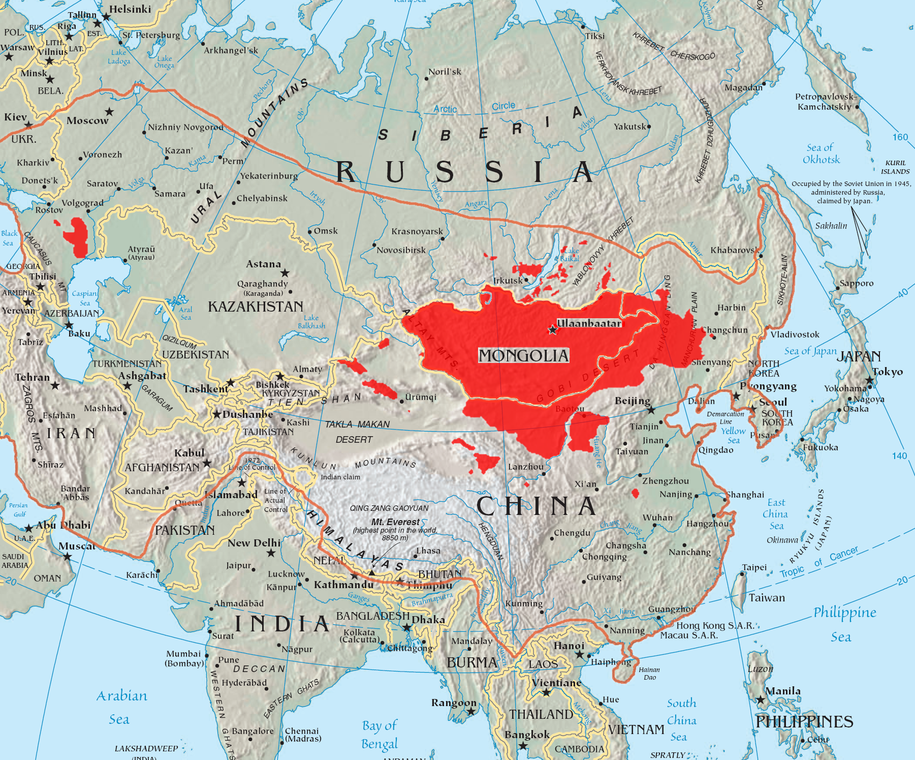
English: A map of the places that Mongol peoples live.
The orange line shows the extent of the Mongol Empire in the late 13th century. The red areas are the places dominated by ethnic Mongols. |
| Tarix | |
| Çıme |
|
| Nuştekar | Quadell |

|
This linguistic map image could be re-created using vector graphics as an SVG file. This has several advantages; see Commons:Media for cleanup for more information. If an SVG form of this image is available, please upload it and afterwards replace this template with
{{vector version available|new image name}}.
It is recommended to name the SVG file “Mongols-map.svg”—then the template Vector version available (or Vva) does not need the new image name parameter. |
Lisans
Ez, ke ena dosya viraste, bine ena lisansan ser cap kena:

|
Şıma şenê ena dosya kopya kerê, vıla kerê ya zi bıvırnê bınê GNU Free Documentation License, Versiyon 1.2 ya zi versiyonane ke cap biye pê Free Software Foundation; pê nê Invariant Sections, nê Front-Cover Texts u nê Back-Cover Texts. You qısımê kopya bine GNU Free Documentation License estê. |
| Ena dosya binê Creative Commons Attribution-Share Alike 3.0 Unported lisans biya. | ||
| ||
| Na etiketa lsansi, Dosya dı yew letey GFDL Lisans kerdışi newekerdışi bo deye debiyayo de. |
Ena dosya binê Creative Commons Attribution-Share Alike 2.0 Generic lisans biya.
- Nê weçenegan dê xoseri:
- bare kerdene – qe gure kopya kerdişi, vila kerdişi u şawitişi
- qe reyna mix kerdişi – qe kabul kerdişi gure
- bine enê şarti:
- gıredayış – Lazımo ke şıma icazet bıdê, lisansi rê link, vuriyayış ke biyo belû kerê. Ney şıma usulên ra şenê bıkerê, labelê karkerdış u iştirakê şıma terefê wayirê lisansi ra zey qebulbiyene yew qeyde çıniyo.
- sey yewbini barekerdış – Meqaleyi ke reyna têv dê, tadê ya zi fına inşa bıkerê, iştırakê şıma lazımo ke zey orcinali same or compatible license bın de vıla kerê.
Ti eskena lisanse xo biwecini.
Verêniya dosya
Seba diyayışê viyarteyê dosya ra tarixê ke qısımê tarix/zemani derê inan bıtıkne.
| Tarix/Zeman | Resımo qıckek | Ebadi | Karber | Mışewre | |
|---|---|---|---|---|---|
| nıkayên | 14:37, 29 Gulane 2023 | | 1,801 - 1,495 (2.79 MB) | Artanisen | High resolution map with the same borders and areas as version 17:34, 16 July 2005 (UTC) |
| 20:13, 10 Nisane 2021 |  | 728 - 525 (279 KB) | Fæ | Reverted to version as of 17:34, 16 July 2005 (UTC) Untrusted work of sockpuppets | |
| 03:35, 17 Çele 2019 |  | 728 - 525 (295 KB) | Anchuhu | mongol | |
| 10:56, 22 Hezirane 2017 |  | 728 - 525 (630 KB) | 일성강 | Reverted to version as of 12:47, 1 June 2017 (UTC) | |
| 08:54, 17 Hezirane 2017 |  | 728 - 525 (279 KB) | Calthinus | Reverted to version as of 17:34, 16 July 2005 (UTC) | |
| 12:47, 1 Hezirane 2017 |  | 728 - 525 (630 KB) | 일성강 | fixed | |
| 17:34, 16 Temuze 2005 |  | 728 - 525 (279 KB) | Hottentot~commonswiki | This is a map of the places that Mongol peoples live. The information is based off of w:en:Image:Mongolsethnic.jpg, and the map I started with is w:en:Image:Asia-map.png. The orange line shows the extent of the Mongol Empire in the late 13th c | |
| 13:14, 16 Temuze 2005 |  | 728 - 525 (297 KB) | Quadell | This is a map of the places that Mongol peoples live. The information is based off of [:w:en:Image:Mongolsethnic.jpg]], and the map I started with is w:en:Image:Asia-map.png. The orange line shows the extent of the Mongol Empire in the late 13th ce |
Gurenayışê dosya
The following pages link to this file:
Gurenayışê dosyaya gılovere
Ena dosya wikiyanê binan de gureniyena.
- af.wikipedia.org sero guriyayış
- an.wikipedia.org sero guriyayış
- ar.wikipedia.org sero guriyayış
- arz.wikipedia.org sero guriyayış
- ast.wikipedia.org sero guriyayış
- azb.wikipedia.org sero guriyayış
- ba.wikipedia.org sero guriyayış
- be-tarask.wikipedia.org sero guriyayış
- be.wikipedia.org sero guriyayış
- bg.wiktionary.org sero guriyayış
- bh.wikipedia.org sero guriyayış
- br.wikipedia.org sero guriyayış
- bs.wikipedia.org sero guriyayış
- ca.wikipedia.org sero guriyayış
- ckb.wikipedia.org sero guriyayış
- cs.wikipedia.org sero guriyayış
- cv.wikipedia.org sero guriyayış
- da.wikipedia.org sero guriyayış
- dsb.wikipedia.org sero guriyayış
- el.wikipedia.org sero guriyayış
- en.wikipedia.org sero guriyayış
Yê na dosya gurenayışê gıloveri tayêna bıvêne.