Dosya:North Sea location map.svg

Ebato oricinale (Dosyay SVGi, nominal 988 × 1,159 pikseli, ebadê dosya: 582 KB)
| Na dosya depoyê Wikimedia Commons de esta u terefê proceyanê binan ra gureniyena. Cêr dê şınasiya dosyay pela mocniyeno. |
Xulasa
| Şınasnayış |
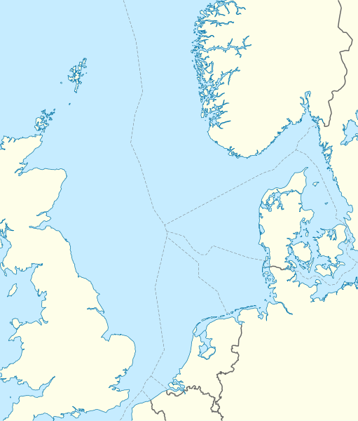
Deutsch: Positionskarte der Nordsee
Quadratische Plattkarte, N-S-Streckung 180 %. Geographische Begrenzung der Karte:
English: Location map of the North Sea
Equirectangular projection, N/S stretching 180 %. Geographic limits of the map:
|
|
| Tarix | ||
| Çıme | own work, using World Data Base II data | |
| Nuştekar | NordNordWest | |
| Destur (Reyna sixulnayise ena dosya) |
Ena dosya binê Creative Commons Attribution-Share Alike 3.0 Germany lisans biya.
 Ena dosya binê Creative Commons Attribution-Share Alike 3.0 Germany lisans biya.
|
|
| Versiyonane binan |
Derivative works of this file:
|


|
This map has been made or improved in the German Kartenwerkstatt (Map Lab). You can propose maps to improve as well.
|
Verêniya dosya
Seba diyayışê viyarteyê dosya ra tarixê ke qısımê tarix/zemani derê inan bıtıkne.
| Tarix/Zeman | Resımo qıckek | Ebadi | Karber | Mışewre | |
|---|---|---|---|---|---|
| nıkayên | 08:49, 18 Hezirane 2010 | | 988 - 1,159 (582 KB) | NordNordWest | == {{int:filedesc}} == {{Information |Description= {{de|Positionskarte der Nordsee}} Quadratische Plattkarte, N-S-Streckung 180 %. Geographische Begrenzung der Karte: * N: 62.5° N * S: 50.5° N * W: 5.2° W * O: 13.2° O {{en|Location map |
Gurenayışê dosya
There are no pages that link to this file.
Gurenayışê dosyaya gılovere
Ena dosya wikiyanê binan de gureniyena.
- ar.wikipedia.org sero guriyayış
- ast.wikipedia.org sero guriyayış
- az.wikipedia.org sero guriyayış
- ban.wikipedia.org sero guriyayış
- be.wikipedia.org sero guriyayış
- ca.wikipedia.org sero guriyayış
- ceb.wikipedia.org sero guriyayış
- cs.wikipedia.org sero guriyayış
- da.wikipedia.org sero guriyayış
- de.wikipedia.org sero guriyayış
- Piper Alpha
- Troll A
- HGÜ Troll
- Ekofisk
- Offshore-Windpark Butendiek
- Wikipedia:Kartenwerkstatt/Positionskarten/Andere
- Offshore-Windpark Rhyl Flats
- Offshore-Windpark North Hoyle
- Offshore-Windpark Borkum Riffgrund
- Offshore-Windpark Sandbank
- Offshore-Windpark DanTysk
- Offshore-Windpark Nördlicher Grund
- Offshore-Windpark Global Tech I
- BARD Offshore 1
- Trianel Windpark Borkum
- Offshore-Windpark Hohe See
- Offshore-Windpark He dreiht
- Offshore-Windpark Veja Mate
- BorWin1
- Offshore-Windpark London Array
- Offshore-Windpark Gwynt y Môr
- Vorlage:Positionskarte Nordsee
- Offshore-Windpark Riffgat
- Gannet Alpha
- Offshore-Windpark Albatros
- Offshore-Windpark Greater Gabbard
- Elgin Wellhead Platform
- Alvheim
- Wikipedia:Auskunft/Archiv/2013/Woche 27
Yê na dosya gurenayışê gıloveri tayêna bıvêne.