Dosya:Plymouth City & Volcano.jpg

Vervênayışê ebadê: 450 × 600 piksel. Agoznayışê bini: 180 × 240 piksel | 360 × 480 piksel | 768 × 1,024 piksel.
Ebato oricinale (768 × 1,024 pikselan, ebatê dosya: 398 KB, MIME tipê cı: image/jpeg)
| Na dosya depoyê Wikimedia Commons de esta u terefê proceyanê binan ra gureniyena. Cêr dê şınasiya dosyay pela mocniyeno. |
Xulasa
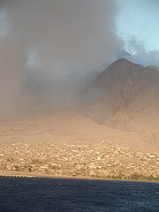
| Şınasnayış | Plymouth Montserrat and the devastation caused by the Soufriere Hills volcano on 25 June, 1997. |
| Tarix | |
| Çıme | Plymouth, Montserrat & Volcano |
| Nuştekar | MikeSchinkel on Flickr.com, MikeSchinkel.com |
| Camera location | | View this and other nearby images on: OpenStreetMap |
|---|
Lisans
Ena dosya bınê lisansê Şarê Afernayoği Gırêdayış 2.0 Bınge de lisans biya.
- Nê weçenegan dê xoseri:
- bare kerdene – qe gure kopya kerdişi, vila kerdişi u şawitişi
- qe reyna mix kerdişi – qe kabul kerdişi gure
- bine enê şarti:
- gıredayış – Lazımo ke şıma icazet bıdê, lisansi rê link, vuriyayış ke biyo belû kerê. Ney şıma usulên ra şenê bıkerê, labelê karkerdış u iştirakê şıma terefê wayirê lisansi ra zey qebulbiyene yew qeyde çıniyo.
| This image was originally posted to Flickr by MikeSchinkel at https://www.flickr.com/photos/13838874@N00/288577947. It was reviewed on 11 Adar 2008 by FlickreviewR and was confirmed to be licensed under the terms of the cc-by-2.0. |
Verêniya dosya
Seba diyayışê viyarteyê dosya ra tarixê ke qısımê tarix/zemani derê inan bıtıkne.
| Tarix/Zeman | Resımo qıckek | Ebadi | Karber | Mışewre | |
|---|---|---|---|---|---|
| nıkayên | 17:38, 11 Adare 2008 | | 768 - 1,024 (398 KB) | Synesthetize | {{Information |Description= Plymouth Montserrat and the devastation caused by the Soufriere Hills volcano on 25 June, 1997. |Source=[http://www.flickr.com/photos/13838874@N00/288577947/ Plymouth, Montserrat & Volcano] |Date=March 11, 2003 at 06:17 |Autho |
Gurenayışê dosya
The following pages link to this file:
Gurenayışê dosyaya gılovere
Ena dosya wikiyanê binan de gureniyena.
- ar.wikipedia.org sero guriyayış
- arz.wikipedia.org sero guriyayış
- ast.wikipedia.org sero guriyayış
- ca.wikipedia.org sero guriyayış
- cy.wikipedia.org sero guriyayış
- da.wikipedia.org sero guriyayış
- en.wikipedia.org sero guriyayış
- en.wikivoyage.org sero guriyayış
- eo.wikipedia.org sero guriyayış
- es.wikipedia.org sero guriyayış
- fr.wikivoyage.org sero guriyayış
- ga.wikipedia.org sero guriyayış
- gl.wikipedia.org sero guriyayış
- ht.wikipedia.org sero guriyayış
- id.wikipedia.org sero guriyayış
- is.wikipedia.org sero guriyayış
- ml.wikipedia.org sero guriyayış
- mt.wikipedia.org sero guriyayış
- pap.wikipedia.org sero guriyayış
- pl.wikipedia.org sero guriyayış
- tl.wikipedia.org sero guriyayış
- www.wikidata.org sero guriyayış