Dosya:Sahel Map-Africa rough.png
Vervênayışê ebadê: 800 × 370 piksel. Agoznayışê bini: 320 × 148 piksel | 640 × 296 piksel | 1,024 × 474 piksel | 2,000 × 925 piksel.
Ebato oricinale (2,000 × 925 pikselan, ebatê dosya: 291 KB, MIME tipê cı: image/png)
| Na dosya depoyê Wikimedia Commons de esta u terefê proceyanê binan ra gureniyena. Cêr dê şınasiya dosyay pela mocniyeno. |

|
This file requires updating because: south soudan In doing so, you could add a timestamp to the file.
|
| Şınasnayış |
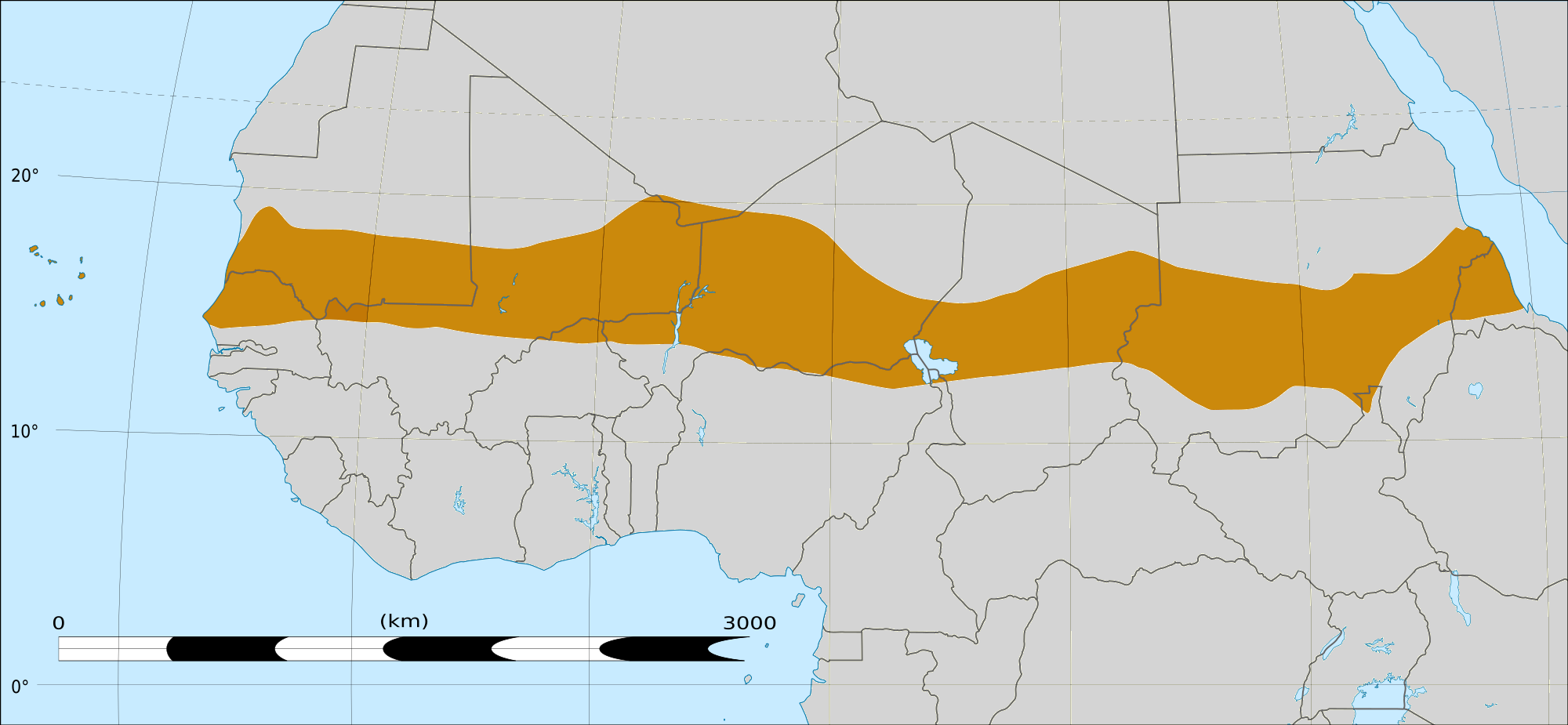
English: Map of Africa, with the Sahel highlighted in orange.
This is roughly the African land area between the lines of 200mm (north) and 600mm (south) mean 20th century annual rainfall. This is limited to land areas directly to the south of the Sahara desert and including the islands of Cape Verde, but not including other areas in Africa with the same rainfall statistics. This is one, but not the only, definition of the Sahel region. |
|||
| Tarix | 20 Sıbate 2009 03:54 (UTC) | |||
| Çıme |
Felix Koenig: "created/photographed by myself (based on the existing blank map of Africa)"
|
|||
| Nuştekar | ||||
| Versiyonane binan |
|


| no fotraf rotuşin biyo, fotrafi sero hebe ki vırnayış biyo. vırnayışi zi: Reproduced Sahel boundary from Map sahel.jpg on png map, cropped.orcinal fotrafo tiya de yo: BlankMap-Africa2.png. fotrafdı sazbiyayış zi T L Miles kerdo.
|
Lisans
Ez, ke ena dosya viraste, bine ena lisansan ser cap kena:

|
Şıma şenê ena dosya kopya kerê, vıla kerê ya zi bıvırnê bınê GNU Free Documentation License, Versiyon 1.2 ya zi versiyonane ke cap biye pê Free Software Foundation; pê nê Invariant Sections, nê Front-Cover Texts u nê Back-Cover Texts. You qısımê kopya bine GNU Free Documentation License estê. |
This file is licensed under the Creative Commons Attribution-Share Alike 4.0 International, 3.0 Unported, 2.5 Generic, 2.0 Generic and 1.0 Generic license.
- Nê weçenegan dê xoseri:
- bare kerdene – qe gure kopya kerdişi, vila kerdişi u şawitişi
- qe reyna mix kerdişi – qe kabul kerdişi gure
- bine enê şarti:
- gıredayış – Lazımo ke şıma icazet bıdê, lisansi rê link, vuriyayış ke biyo belû kerê. Ney şıma usulên ra şenê bıkerê, labelê karkerdış u iştirakê şıma terefê wayirê lisansi ra zey qebulbiyene yew qeyde çıniyo.
- sey yewbini barekerdış – Meqaleyi ke reyna têv dê, tadê ya zi fına inşa bıkerê, iştırakê şıma lazımo ke zey orcinali same or compatible license bın de vıla kerê.
Ti eskena lisanse xo biwecini.
|
|
Şıma şenê ena dosya kopya kerê, vıla kerê ya zi bıvırnê bınê GNU Free Documentation License, Versiyon 1.2 ya zi versiyonane ke cap biye pê Free Software Foundation; pê nê Invariant Sections, nê Front-Cover Texts u nê Back-Cover Texts. You qısımê kopya bine GNU Free Documentation License estê. |
Qeydê barkerdışê oricinali
This image is a derivative work of the following images:
- File:Map_sahel.jpg licensed with GFDL
- 2005-05-30T17:36:46Z King 800x800 (89588 Bytes) one moment please
- File:BlankMap-Africa2.png licensed with Cc-by-sa-3.0,2.5,2.0,1.0, GFDL
- 2008-03-08T18:02:20Z Sadalmelik 1754x1546 (51013 Bytes) {{Information |Description=Blank map of Africa |Source=self-made |Date=2008-03-08 |Author= [[User:Sadalmelik|Sadalmelik]] |Permission= |other_versions= }} [[Category:Blank maps of Africa]]
Uploaded with derivativeFX
Verêniya dosya
Seba diyayışê viyarteyê dosya ra tarixê ke qısımê tarix/zemani derê inan bıtıkne.
| Tarix/Zeman | Resımo qıckek | Ebadi | Karber | Mışewre | |
|---|---|---|---|---|---|
| nıkayên | 16:15, 17 Adare 2018 | | 2,000 - 925 (291 KB) | Maphobbyist | South Sudan border |
| 04:02, 20 Şıbat 2009 |  | 1,384 - 658 (29 KB) | T L Miles | {{Information |Description=*Description: A map of Africa: the Sahel highlighted in orange. Note, this is ROUGHLY the African land area between the lines of 200mm (north) and 600mm (south) mean 20th century annual rainfall. This is limited to land areas d |
Gurenayışê dosya
There are no pages that link to this file.
Gurenayışê dosyaya gılovere
Ena dosya wikiyanê binan de gureniyena.
- af.wikipedia.org sero guriyayış
- als.wikipedia.org sero guriyayış
- ar.wikipedia.org sero guriyayış
- az.wikipedia.org sero guriyayış
- bcl.wikipedia.org sero guriyayış
- be.wikipedia.org sero guriyayış
- bg.wikipedia.org sero guriyayış
- bn.wikipedia.org sero guriyayış
- br.wikipedia.org sero guriyayış
- ca.wikipedia.org sero guriyayış
- ce.wikipedia.org sero guriyayış
- da.wikipedia.org sero guriyayış
- en.wikipedia.org sero guriyayış
- eu.wikipedia.org sero guriyayış
- fa.wikipedia.org sero guriyayış
- fi.wiktionary.org sero guriyayış
- fr.wikipedia.org sero guriyayış
- fr.wikinews.org sero guriyayış
- ha.wikipedia.org sero guriyayış
- ig.wikipedia.org sero guriyayış
- incubator.wikimedia.org sero guriyayış
- it.wikipedia.org sero guriyayış
- ja.wikipedia.org sero guriyayış
- ka.wikipedia.org sero guriyayış
- ko.wikipedia.org sero guriyayış
- mg.wikipedia.org sero guriyayış
- mk.wikipedia.org sero guriyayış
Yê na dosya gurenayışê gıloveri tayêna bıvêne.