Dosya:Sinai-peninsula-map.jpg

Vervênayışê ebadê: 483 × 600 piksel. Agoznayışê bini: 193 × 240 piksel | 387 × 480 piksel | 941 × 1,168 piksel.
Ebato oricinale (941 × 1,168 pikselan, ebatê dosya: 665 KB, MIME tipê cı: image/jpeg)
| Na dosya depoyê Wikimedia Commons de esta u terefê proceyanê binan ra gureniyena. Cêr dê şınasiya dosyay pela mocniyeno. |
فلسطين
Xulasa
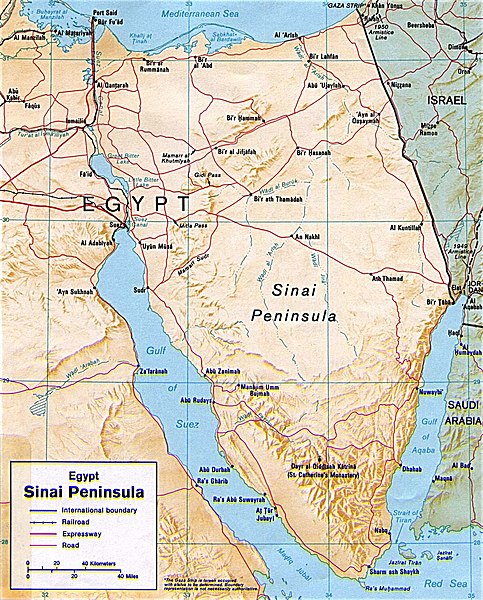
| Şınasnayış | Shaded relief map of the Sinai Peninsula, 1992, produced by the U.S. Central Intelligence Agency. |
| Tarix | |
| Çıme | University of Texas Libraries, Perry-Castañeda Library Map Collection: Egypt Maps |
| Nuştekar | CIA |
| Versiyonane binan |
|


Lisans
| This image is a work of a Central Intelligence Agency employee, taken or made as part of that person's official duties. As a Work of the United States Government, this image or media is in the public domain in the United States.
|

|
Verêniya dosya
Seba diyayışê viyarteyê dosya ra tarixê ke qısımê tarix/zemani derê inan bıtıkne.
| Tarix/Zeman | Resımo qıckek | Ebadi | Karber | Mışewre | |
|---|---|---|---|---|---|
| nıkayên | 20:45, 12 Gulane 2011 | | 941 - 1,168 (665 KB) | Ras67 | cropped |
| 22:58, 4 Adare 2007 |  | 956 - 1,196 (307 KB) | Joao Xavier | Map of the Sinai Peninsula. (U.S. Central Intelligence Agency, https://www.cia.gov/cia/publications/mapspub/index.shtml) originally found on University of Texas library website (http://www.lib.utexas.edu/maps/middle_east_and_asia/sinai.jpg) and claimed as |
Gurenayışê dosya
The following pages link to this file:
Gurenayışê dosyaya gılovere
Ena dosya wikiyanê binan de gureniyena.
- af.wikipedia.org sero guriyayış
- als.wikipedia.org sero guriyayış
- ar.wikipedia.org sero guriyayış
- ast.wikipedia.org sero guriyayış
- azb.wikipedia.org sero guriyayış
- az.wikipedia.org sero guriyayış
- az.wiktionary.org sero guriyayış
- ba.wikipedia.org sero guriyayış
- bn.wikipedia.org sero guriyayış
- bs.wikipedia.org sero guriyayış
- ca.wikipedia.org sero guriyayış
- cs.wikipedia.org sero guriyayış
- da.wikipedia.org sero guriyayış
- de.wikipedia.org sero guriyayış
- de.wikinews.org sero guriyayış
- de.wiktionary.org sero guriyayış
- el.wikipedia.org sero guriyayış
- el.wiktionary.org sero guriyayış
- en.wikipedia.org sero guriyayış
- eo.wikipedia.org sero guriyayış
- es.wikipedia.org sero guriyayış
- eu.wikipedia.org sero guriyayış
Yê na dosya gurenayışê gıloveri tayêna bıvêne.