Dosya:Soudelor 2015-08-04 0410Z.jpg

Vervênayışê ebadê: 463 × 599 piksel. Agoznayışê bini: 185 × 240 piksel | 371 × 480 piksel | 593 × 768 piksel | 791 × 1,024 piksel | 1,582 × 2,048 piksel | 6,800 × 8,800 piksel.
Ebato oricinale (6,800 × 8,800 pikselan, ebatê dosya: 7.89 MB, MIME tipê cı: image/jpeg)
| Na dosya depoyê Wikimedia Commons de esta u terefê proceyanê binan ra gureniyena. Cêr dê şınasiya dosyay pela mocniyeno. |
Xulasa
| Şınasnayış |
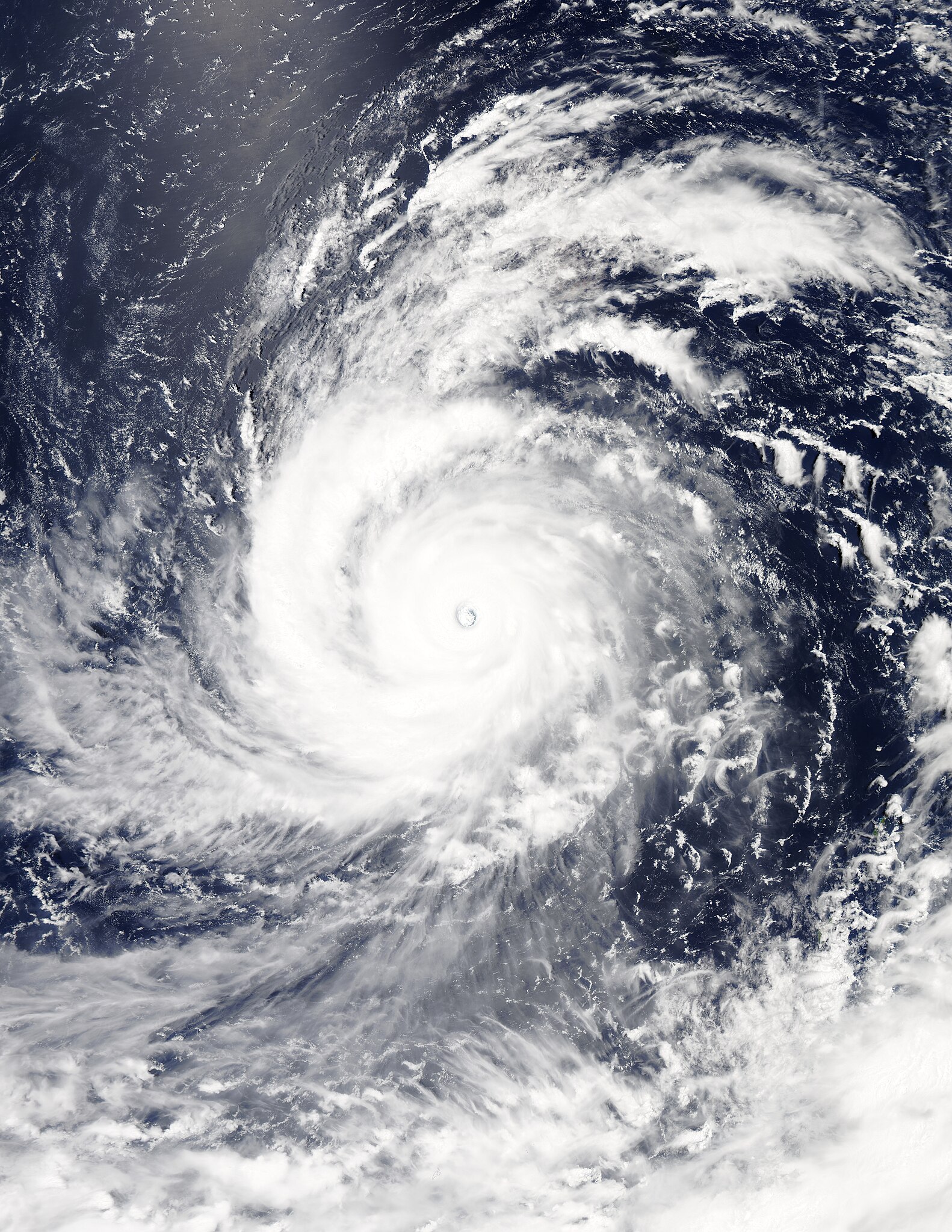
English: Typhoon Soudelor at peak intensity on August 4, 2015. |
| Tarix | |
| Çıme | Rapid Response - LANCE |
| Nuştekar | MODIS image captured by NASA’s Aqua satellite |
| Camera location | | View this and other nearby images on: OpenStreetMap |
|---|
Lisans
| This file is in the public domain in the United States because it was solely created by NASA. NASA copyright policy states that "NASA material is not protected by copyright unless noted". (See Template:PD-USGov, NASA copyright policy page or JPL Image Use Policy.) | ||
 |
Warnings:
|
Verêniya dosya
Seba diyayışê viyarteyê dosya ra tarixê ke qısımê tarix/zemani derê inan bıtıkne.
| Tarix/Zeman | Resımo qıckek | Ebadi | Karber | Mışewre | |
|---|---|---|---|---|---|
| nıkayên | 14:43, 5 Keşkelun 2023 | | 6,800 - 8,800 (7.89 MB) | Nino Marakot | Reverted to version as of 11:35, 4 August 2015 (UTC) Such version already exists at File:Soudelor 2015-08-04 0405Z.jpg |
| 19:14, 17 Tebaxe 2022 |  | 6,800 - 8,800 (26.96 MB) | TheWxResearcher | Tweaked Brightness so the structure of the storm would be more visible. | |
| 11:35, 4 Tebaxe 2015 |  | 6,800 - 8,800 (7.89 MB) | Nino Marakot | Gallery | |
| 09:02, 4 Tebaxe 2015 |  | 7,521 - 8,561 (6.17 MB) | Nino Marakot | User created page with UploadWizard |
Gurenayışê dosya
The following pages link to this file:
Gurenayışê dosyaya gılovere
Ena dosya wikiyanê binan de gureniyena.
- ar.wikipedia.org sero guriyayış
- de.wikipedia.org sero guriyayış
- en.wikipedia.org sero guriyayış
- es.wikipedia.org sero guriyayış
- fr.wikipedia.org sero guriyayış
- id.wikipedia.org sero guriyayış
- ja.wikipedia.org sero guriyayış
- ko.wikipedia.org sero guriyayış
- ms.wikipedia.org sero guriyayış
- pt.wikipedia.org sero guriyayış
- th.wikipedia.org sero guriyayış
- tl.wikipedia.org sero guriyayış
- uk.wikipedia.org sero guriyayış
- vi.wikipedia.org sero guriyayış
- zh.wikipedia.org sero guriyayış