Dosya:Spain, Catalonia, Muntanyola, Múnter.JPG

Vervênayışê ebadê: 800 × 531 piksel. Agoznayışê bini: 320 × 213 piksel | 640 × 425 piksel | 1,024 × 680 piksel | 1,280 × 850 piksel | 2,144 × 1,424 piksel.
Ebato oricinale (2,144 × 1,424 pikselan, ebatê dosya: 728 KB, MIME tipê cı: image/jpeg)
| Na dosya depoyê Wikimedia Commons de esta u terefê proceyanê binan ra gureniyena. Cêr dê şınasiya dosyay pela mocniyeno. |
This is a photo of a building indexed in the Catalan heritage register as Bé Cultural d'Interès Local (BCIL) under the reference IPA-23129 (Església de Sant Esteve de Múnter). |
This is a photo of a building indexed in the Catalan heritage register as Bé Cultural d'Interès Local (BCIL) under the reference IPA-23131 (Rectoria de Sant Esteve de Múnter). |
Xulasa
| Şınasnayış |
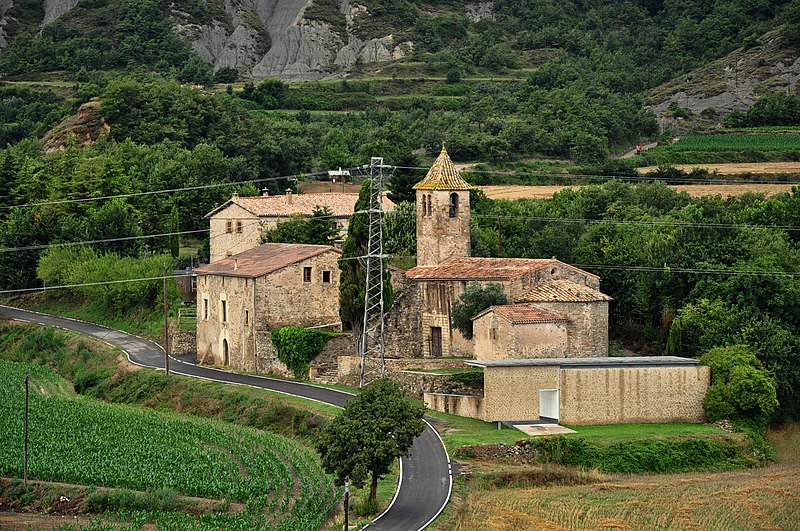
Català: Església parroquial de Sant Esteve de Múnter (municipi Muntanyola, comarca Osona, Catalunya, Espanya). Forma un petit conjunt amb una masia i la rectoria. La rectoria és una gran masia catalana. El temple parroquial és d'origen romànic, però va ser molt transformat el segle XVII.
Nederlands: Parochiekerk van St. Stefanus in het gehucht Múnter (gemeente Muntanyola, district/comarca Osona, Catalonië, Spanje). De kerk vormt een kleine groep met een huis en de pastorie. De pastorie is een grote Catalaanse boerderij. De kerk is van Romaanse oorsprong, maar is in de 17e eeuw sterk verbouwd.
English: Parish Church of St. Stephen in the hamlet of Múnter (Muntanyola municipality, county Osona, Catalonia, Spain). The church forms a small group with a house and the rectory. The rectory is a large Catalan farmhouse. The church is of Romanesque origin, but was transformed in the 17th century.
Español: Iglesia parroquial de San Esteban de Múnter (municipio Muntanyola, comarca Osona, Cataluña, España). Forma un pequeño conjunto con una masía y la rectoría. La rectoría es una gran masía catalana. El templo parroquial es de origen románico, pero fue muy transformado el siglo XVII. |
| Tarix | |
| Çıme | Karo şexsi |
| Nuştekar | Vincent van Zeijst |
| Object location | | View this and other nearby images on: OpenStreetMap |
|---|
| Camera location | | View this and other nearby images on: OpenStreetMap |
|---|
Lisans
Ez, ke ena dosya viraste, bine ena lisans ser cap kena:
Ena dosya binê Creative Commons Attribution-Share Alike 3.0 Unported lisans biya.
- Nê weçenegan dê xoseri:
- bare kerdene – qe gure kopya kerdişi, vila kerdişi u şawitişi
- qe reyna mix kerdişi – qe kabul kerdişi gure
- bine enê şarti:
- gıredayış – Lazımo ke şıma icazet bıdê, lisansi rê link, vuriyayış ke biyo belû kerê. Ney şıma usulên ra şenê bıkerê, labelê karkerdış u iştirakê şıma terefê wayirê lisansi ra zey qebulbiyene yew qeyde çıniyo.
- sey yewbini barekerdış – Meqaleyi ke reyna têv dê, tadê ya zi fına inşa bıkerê, iştırakê şıma lazımo ke zey orcinali same or compatible license bın de vıla kerê.
Verêniya dosya
Seba diyayışê viyarteyê dosya ra tarixê ke qısımê tarix/zemani derê inan bıtıkne.
| Tarix/Zeman | Resımo qıckek | Ebadi | Karber | Mışewre | |
|---|---|---|---|---|---|
| nıkayên | 21:17, 10 Şıbat 2012 | | 2,144 - 1,424 (728 KB) | Loranchet | {{Information |Description ={{ca|1=Església parroquial de Sant Esteve de Múnter (municipi Muntanyola, comarca Osona, Catalunya, Espanya). Forma un petit conjunt amb una masia i la rectoria. La rectoria és una gran masia catalana. El temple parroquia |
Gurenayışê dosya
The following pages link to this file:
Gurenayışê dosyaya gılovere
Ena dosya wikiyanê binan de gureniyena.
- ar.wikipedia.org sero guriyayış
- ast.wikipedia.org sero guriyayış
- ca.wikipedia.org sero guriyayış
- ceb.wikipedia.org sero guriyayış
- ce.wikipedia.org sero guriyayış
- en.wikipedia.org sero guriyayış
- es.wikipedia.org sero guriyayış
- eu.wikipedia.org sero guriyayış
- fr.wikipedia.org sero guriyayış
- gl.wikipedia.org sero guriyayış
- hu.wikipedia.org sero guriyayış
- hy.wikipedia.org sero guriyayış
- ia.wikipedia.org sero guriyayış
- it.wikipedia.org sero guriyayış
- la.wikipedia.org sero guriyayış
- lld.wikipedia.org sero guriyayış
- lmo.wikipedia.org sero guriyayış
- pl.wikipedia.org sero guriyayış
- pt.wikipedia.org sero guriyayış
- ro.wikipedia.org sero guriyayış
- ru.wikipedia.org sero guriyayış
- sv.wikipedia.org sero guriyayış
- tt.wikipedia.org sero guriyayış
- uz.wikipedia.org sero guriyayış
- vec.wikipedia.org sero guriyayış
- www.wikidata.org sero guriyayış