Dosya:Sy-map.png
Deha berz agozney cı çıniyo
Sy-map.png (326 × 350 pikselan, ebatê dosya: 11 KB, MIME tipê cı: image/png)
| Na dosya depoyê Wikimedia Commons de esta u terefê proceyanê binan ra gureniyena. Cêr dê şınasiya dosyay pela mocniyeno. |

|
This locator map image could be re-created using vector graphics as an SVG file. This has several advantages; see Commons:Media for cleanup for more information. If an SVG form of this image is available, please upload it and afterwards replace this template with
{{vector version available|new image name}}.
It is recommended to name the SVG file “Sy-map.svg”—then the template Vector version available (or Vva) does not need the new image name parameter. |
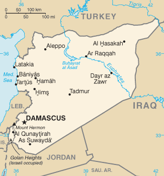
CIA map of Syria
|
|
 |
Verêniya dosya
Seba diyayışê viyarteyê dosya ra tarixê ke qısımê tarix/zemani derê inan bıtıkne.
| Tarix/Zeman | Resımo qıckek | Ebadi | Karber | Mışewre | |
|---|---|---|---|---|---|
| nıkayên | 13:04, 14 Çele 2011 | | 326 - 350 (11 KB) | Ras67 | cropped |
| 07:59, 11 Çele 2009 |  | 328 - 353 (12 KB) | Timeshifter | Latest version of the map from the CIA Factbook page for Syria. That page was last updated Dec. 18, 2008. I converted the GIF image to PNG using the freeware IrfanView PNGOUT to losslessly compress the image to palette PNG. | |
| 13:35, 12 Gulane 2005 |  | 328 - 352 (12 KB) | Eirik | CIA map of syria {{PD-USGov-CIA-WF}} Category:Maps of Syria |
Gurenayışê dosya
The following pages link to this file:
Gurenayışê dosyaya gılovere
Ena dosya wikiyanê binan de gureniyena.
- ace.wikipedia.org sero guriyayış
- ar.wikipedia.org sero guriyayış
- azb.wikipedia.org sero guriyayış
- be-tarask.wikipedia.org sero guriyayış
- bg.wikipedia.org sero guriyayış
- bg.wiktionary.org sero guriyayış
- br.wikipedia.org sero guriyayış
- ca.wikipedia.org sero guriyayış
- ca.wikinews.org sero guriyayış
- da.wikipedia.org sero guriyayış
- de.wikipedia.org sero guriyayış
- de.wikinews.org sero guriyayış
- dsb.wikipedia.org sero guriyayış
- el.wikipedia.org sero guriyayış
- el.wikinews.org sero guriyayış
- en.wikipedia.org sero guriyayış
- en.wikinews.org sero guriyayış
- en.wikiquote.org sero guriyayış
- en.wiktionary.org sero guriyayış
- eo.wikipedia.org sero guriyayış
- fi.wikipedia.org sero guriyayış
- fr.wikipedia.org sero guriyayış
- fr.wikinews.org sero guriyayış
- gl.wikipedia.org sero guriyayış
- gu.wikipedia.org sero guriyayış
- hif.wikipedia.org sero guriyayış
- hi.wikipedia.org sero guriyayış
- hi.wiktionary.org sero guriyayış
- id.wikipedia.org sero guriyayış
- incubator.wikimedia.org sero guriyayış
- ja.wikipedia.org sero guriyayış
- jv.wikipedia.org sero guriyayış
- ko.wiktionary.org sero guriyayış
- mai.wikipedia.org sero guriyayış
- mr.wikipedia.org sero guriyayış
- ms.wikipedia.org sero guriyayış
Yê na dosya gurenayışê gıloveri tayêna bıvêne.