Dosya:Trebizond1300.png
Deha berz agozney cı çıniyo
Trebizond1300.png (552 × 392 pikselan, ebatê dosya: 67 KB, MIME tipê cı: image/png)
| Na dosya depoyê Wikimedia Commons de esta u terefê proceyanê binan ra gureniyena. Cêr dê şınasiya dosyay pela mocniyeno. |
Xulasa
| Şınasnayış |
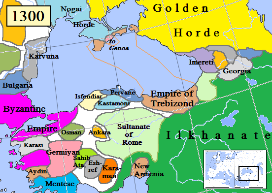
English: Map of the Trebizond Empire in Anatolia, AD 1300.
(Partially based on Euratlas map of Europe, 1300.) |
| Tarix | |
| Çıme | Karo şexsi |
| Nuştekar | Gabagool |

|
This historical map image could be re-created using vector graphics as an SVG file. This has several advantages; see Commons:Media for cleanup for more information. If an SVG form of this image is available, please upload it and afterwards replace this template with
{{vector version available|new image name}}.
It is recommended to name the SVG file “Trebizond1300.svg”—then the template Vector version available (or Vva) does not need the new image name parameter. |
Lisans
Ez, ke ena dosya viraste, bine ena lisans ser cap kena:
Ena dosya binê Creative Commons Attribution 3.0 Unported lisans biya.
- Nê weçenegan dê xoseri:
- bare kerdene – qe gure kopya kerdişi, vila kerdişi u şawitişi
- qe reyna mix kerdişi – qe kabul kerdişi gure
- bine enê şarti:
- gıredayış – Lazımo ke şıma icazet bıdê, lisansi rê link, vuriyayış ke biyo belû kerê. Ney şıma usulên ra şenê bıkerê, labelê karkerdış u iştirakê şıma terefê wayirê lisansi ra zey qebulbiyene yew qeyde çıniyo.
Verêniya dosya
Seba diyayışê viyarteyê dosya ra tarixê ke qısımê tarix/zemani derê inan bıtıkne.
| Tarix/Zeman | Resımo qıckek | Ebadi | Karber | Mışewre | |
|---|---|---|---|---|---|
| nıkayên | 15:21, 12 Tebaxe 2023 | | 552 - 392 (67 KB) | Gyalu22 | Reverted to version as of 16:24, 16 November 2022 (UTC) Wallachia was not part of the Second Bulgarian Empire, see https://www.google.com/search?q=europe+map+1300 |
| 15:09, 12 Gulane 2023 |  | 564 - 404 (143 KB) | Moodylo333 | Correct borders & states year 1300 | |
| 16:24, 16 Tışrino Peyên 2022 |  | 552 - 392 (67 KB) | Gyalu22 | Reverted to version as of 00:49, 13 December 2012 (UTC) | |
| 17:46, 15 Tebaxe 2019 |  | 552 - 392 (94 KB) | Georgiano | Reverted to version as of 17:44, 15 August 2019 (UTC) correct source: File:Map–Principality of Samtskhe till c.1325–ka.svg | |
| 17:45, 15 Tebaxe 2019 |  | 552 - 392 (89 KB) | Georgiano | Reverted to version as of 23:21, 2 April 2016 (UTC) | |
| 17:44, 15 Tebaxe 2019 |  | 552 - 392 (94 KB) | Georgiano | added Principality of Samtskhe (vassal of Ilkhanate between 1266–1334) source: File:Caucasus 1311 AD map de.png | |
| 23:21, 2 Nisane 2016 |  | 552 - 392 (89 KB) | Julieta39 | Cosmetic work, add Amastris, Montecastro, Caffa & Cembalo (to Genoa) and some details according with Claude Mutafian & Eric Van Lauwe’s « Atlas Historique de l’Armenie », Paris, ed. Autrement 2001, ISBN 2-7467-0100-6 | |
| 20:06, 14 Adare 2016 |  | 552 - 392 (75 KB) | Georgiano | fixed borders of Georgian kingdoms | |
| 10:25, 17 Temuze 2015 |  | 552 - 392 (89 KB) | Spiridon Ion Cepleanu | Little rectifications. according with H.E.Stier's (dir.) « Westermann Grosser Atlas zur Weltgeschichte », 1985, ISBN 3-14-100919-8 for the year 1300 | |
| 00:49, 13 Kanun 2012 |  | 552 - 392 (67 KB) | Geagea | Reverted to version as of 19:54, 30 March 2009 |
Gurenayışê dosya
The following pages link to this file:
Gurenayışê dosyaya gılovere
Ena dosya wikiyanê binan de gureniyena.
- ar.wikipedia.org sero guriyayış
- azb.wikipedia.org sero guriyayış
- az.wikipedia.org sero guriyayış
- be.wikipedia.org sero guriyayış
- bg.wikipedia.org sero guriyayış
- cs.wikipedia.org sero guriyayış
- dsb.wikipedia.org sero guriyayış
- el.wikipedia.org sero guriyayış
- en.wikipedia.org sero guriyayış
- es.wikipedia.org sero guriyayış
- et.wikipedia.org sero guriyayış
- eu.wikipedia.org sero guriyayış
- fa.wikipedia.org sero guriyayış
- fiu-vro.wikipedia.org sero guriyayış
- fr.wikipedia.org sero guriyayış
- gl.wikipedia.org sero guriyayış
- hr.wikipedia.org sero guriyayış
- hu.wikipedia.org sero guriyayış
- hy.wikipedia.org sero guriyayış
- id.wikipedia.org sero guriyayış
- it.wikipedia.org sero guriyayış
- ka.wikipedia.org sero guriyayış
- ku.wikipedia.org sero guriyayış
- lt.wikipedia.org sero guriyayış
- mk.wikipedia.org sero guriyayış
- ms.wikipedia.org sero guriyayış
- nl.wikipedia.org sero guriyayış
Yê na dosya gurenayışê gıloveri tayêna bıvêne.