Dosya:Uruguay T2.png

Vervênayışê ebadê: 527 × 599 piksel. Agoznayışê bini: 211 × 240 piksel | 422 × 480 piksel | 691 × 786 piksel.
Ebato oricinale (691 × 786 pikselan, ebatê dosya: 1.18 MB, MIME tipê cı: image/png)
| Na dosya depoyê Wikimedia Commons de esta u terefê proceyanê binan ra gureniyena. Cêr dê şınasiya dosyay pela mocniyeno. |
Xulasa
| Şınasnayış |
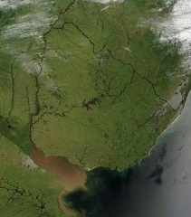
Español: Foto de Uruguay tomada desde satélite. Se aprecian claramente los límites con Brasil y Argentina, y el Río de la Plata al sur.
English: Photo of Uruguay taken from satellite, where the limits with Brazil and Argentina are clearly appreciated, as well as the Río de la Plata to the south. |
| Tarix | |
| Çıme | http://visibleearth.nasa.gov/view_rec.php?id=4817 |
| Nuştekar | Jeff Schmaltz, MODIS Rapid Response Team, NASA/GSFC |
Lisans
| This file is in the public domain in the United States because it was solely created by NASA. NASA copyright policy states that "NASA material is not protected by copyright unless noted". (See Template:PD-USGov, NASA copyright policy page or JPL Image Use Policy.) | ||
 |
Warnings:
|
Verêniya dosya
Seba diyayışê viyarteyê dosya ra tarixê ke qısımê tarix/zemani derê inan bıtıkne.
| Tarix/Zeman | Resımo qıckek | Ebadi | Karber | Mışewre | |
|---|---|---|---|---|---|
| nıkayên | 04:11, 29 Tışrino Peyên 2004 | | 691 - 786 (1.18 MB) | Tano4595 | Uruguay_satelite |
Gurenayışê dosya
There are no pages that link to this file.
Gurenayışê dosyaya gılovere
Ena dosya wikiyanê binan de gureniyena.
- af.wikipedia.org sero guriyayış
- als.wikipedia.org sero guriyayış
- an.wikipedia.org sero guriyayış
- ar.wikipedia.org sero guriyayış
- ast.wikipedia.org sero guriyayış
- azb.wikipedia.org sero guriyayış
- ba.wikipedia.org sero guriyayış
- bg.wikipedia.org sero guriyayış
- ca.wikipedia.org sero guriyayış
- cs.wikipedia.org sero guriyayış
- da.wikipedia.org sero guriyayış
- de.wikipedia.org sero guriyayış
- el.wikipedia.org sero guriyayış
- en.wikipedia.org sero guriyayış
- en.wikibooks.org sero guriyayış
- eo.wikipedia.org sero guriyayış
- es.wikipedia.org sero guriyayış
- eu.wikipedia.org sero guriyayış
- fr.wikipedia.org sero guriyayış
- gcr.wikipedia.org sero guriyayış
- hi.wikipedia.org sero guriyayış
- hr.wikipedia.org sero guriyayış
- hu.wikipedia.org sero guriyayış
- hy.wikipedia.org sero guriyayış
- hyw.wikipedia.org sero guriyayış
- is.wikipedia.org sero guriyayış
- it.wikipedia.org sero guriyayış
- ku.wikipedia.org sero guriyayış
- la.wikipedia.org sero guriyayış
- li.wikipedia.org sero guriyayış
- lv.wikipedia.org sero guriyayış
- ms.wikipedia.org sero guriyayış
- mt.wikipedia.org sero guriyayış
- oc.wikipedia.org sero guriyayış
- os.wikipedia.org sero guriyayış
- pcd.wikipedia.org sero guriyayış
- pl.wikipedia.org sero guriyayış
Yê na dosya gurenayışê gıloveri tayêna bıvêne.