Dosya:Windmills D1-D4 (Thornton Bank).jpg
Vervênayışê ebadê: 388 × 600 piksel. Agoznayışê bini: 155 × 240 piksel | 310 × 480 piksel | 496 × 768 piksel | 662 × 1,024 piksel | 1,324 × 2,048 piksel | 2,676 × 4,138 piksel.
Ebato oricinale (2,676 × 4,138 pikselan, ebatê dosya: 5.81 MB, MIME tipê cı: image/jpeg)
| Na dosya depoyê Wikimedia Commons de esta u terefê proceyanê binan ra gureniyena. Cêr dê şınasiya dosyay pela mocniyeno. |
.jpg)
Xulasa
| Camera location | | View this and other nearby images on: OpenStreetMap |
|---|
.jpg¶ms=051.545500_N_0002.929850_E_globe:Earth_type:camera__&language=diq)
| Fotrafwan |
Hans Hillewaert |
| Şınasnayış |
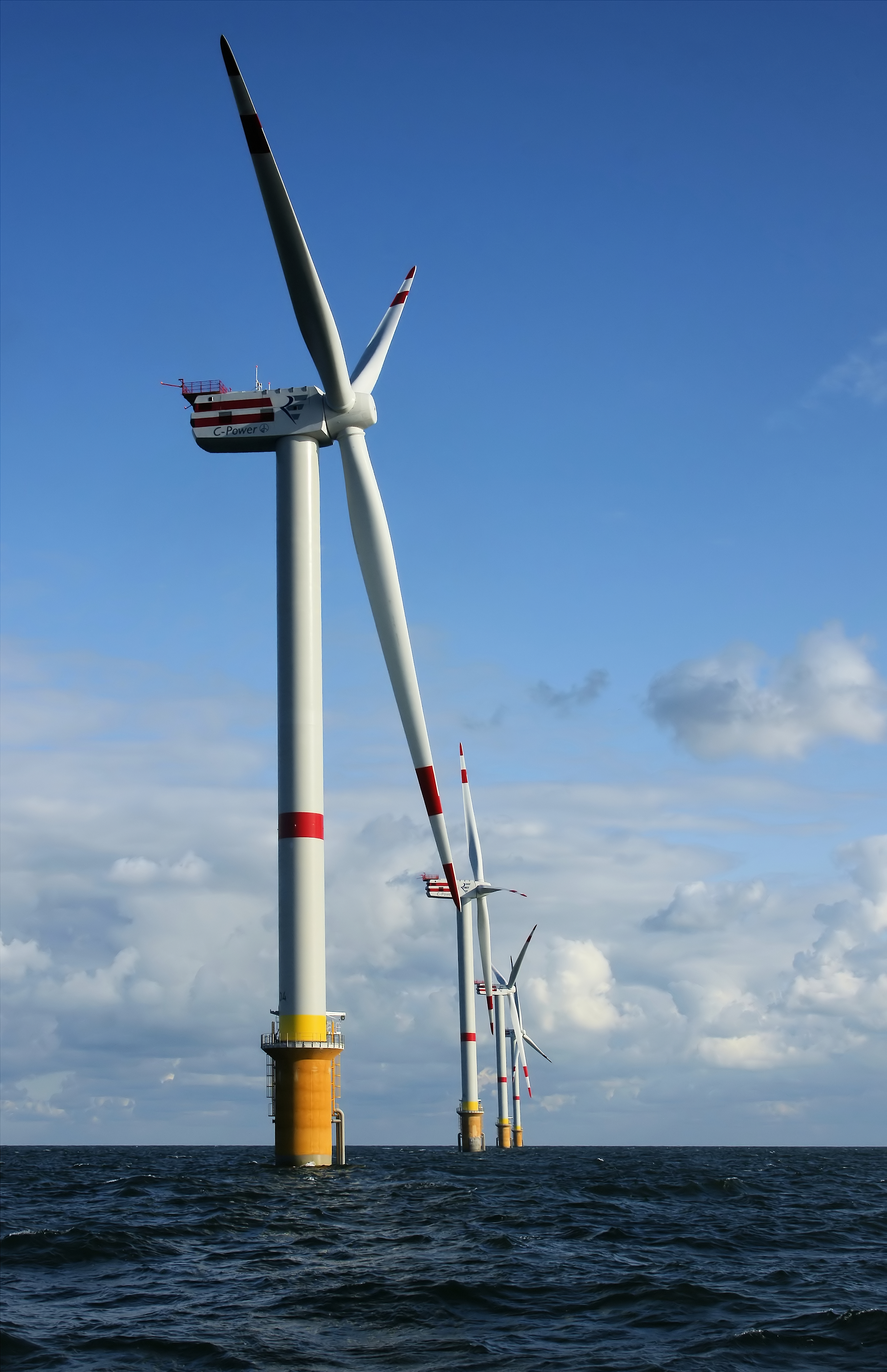
العربية: عنفات رياح حديثة الإنشاء، تُرى بدايةً من العنفة D4 (الأقرب) إلى العنفة D1، على ضفة ثورنتون، الواقعة على بُعد 28 كلم عن اليابسة، في القسم البلجيكي من بحر الشمال. يبلغ ارتفاع العنفة الواحدة انطلاقًا من سطح الماء 157 مترًا (+ مراوحها)، وعند احتساب ارتفاعها الكامل انطلاقًا من قاع البحر فإنها تصل إلى 184 مترًا.
English: Newly constructed windmills D4 (nearest) to D1 on the Thornton Bank, 28 km off shore, on the Belgian part of the North Sea. The windmills are 157 m (+TAW) high, 184 m above the sea bottom.
Français : Éoliennes D4 (au premier plan) à D1 (en arrière plan) ; nouvellement construites sur le banc Thornton, à 28 kilomètres de la côte belge, dans la Mer du Nord. Ces éoliennes mesurent 157 m de haut (plus les ailes), soit 184m au dessus du fond marin. |
| Tarix | 29 Keşkelun 2008 |
| Çıme | Karo şexsi |
| Destur (Reyna sixulnayise ena dosya) |
Creative Commons Attribution-Share Alike 4.0 Internasyonel de ena dosya lisans biya. Gırêdayış: © Hans Hillewaert
|
| Other licenses | More (4100+) and new images on : High resolution files on request. . |
| Gırêdayış (required by the license) | © Hans Hillewaert / |
|
.jpg)
.jpg)
.jpg)
.jpg)
.jpg)
This image was selected as picture of the day on Wikimedia Commons for 16 March 2012. It was captioned as follows: English: Newly constructed windmills on the Thornton Bank, 28 km off shore, on the Belgian part of the North Sea. The windmills are 157 m high, 184 m above the sea bottom. Other languages:
Dansk: Nyopførte vindmøller på Thornton Bank, 28 km uden for kysten i den belgiske del af Nordsøen. Møllerne er 157 m.o.h., 184 m høje fra havbunden. English: Newly constructed windmills on the Thornton Bank, 28 km off shore, on the Belgian part of the North Sea. The windmills are 157 m high, 184 m above the sea bottom. Español: Generadores eólicos recién construidos en Thorntonbank, 28 km mar adentro, en la parte belga del Mar del Norte. Los molinos tienen 157 m de alto, 184 m desde el fondo marino. Français : Éoliennes nouvellement construites sur le banc Thornton, à 28 kilomètres de la côte belge, dans la Mer du Nord. Ces éoliennes mesurent 157 m de haut (plus les ailes), soit 184 m au dessus du fond marin. Italiano: Mulini a vento sul Thornton Bank, 28 km al largo delle coste belghe nel Mare del Nord in acque profonde da 12 a 27 metri. Nederlands: Nieuw geconstrueerde windmolens op de Thorntonbank 28 kilometer offshore in het Belgische deel van de Noordzee. De windmolens zijn 157 meter (+TAW) hoog en bevinden zich 184 meter boven de zeebodem. Polski: Turbiny wiatrowe na farmie Thornton Bank na Morzu Północnym, oddalone 28 km od belgijskiego brzegu. Wiatraki mają 157 m wysokości (184 m od dna morskiego). Македонски: Новоизградени ветерни турбини на гребенот Торнтонбанк, 28 км од белгискиот брег на Северното Море. Українська: Вітрогенератори (від D4 (найближчий) до D1, всього їх шість) Вітряної електростанції на обмілині Торнтон (фр. Parc éolien de Thorntonbank) за 28 км від узбережжя в бельгійських територіальних водах Північного моря. Висота вітрогенератора, враховуючи довжину лопаті — 157 м, загальна висота над дном моря — 184 м. 日本語: 北海ベルギー領の沖合28キロメートル洋上に建設中のソーントンバンク風力発電所。風車は高さ157メートルで、海底から184メートル上にある。 中文: 北海比利时桑顿海滩新建的风车,风车高度157米,从海底计算高度为184米。 |
Verêniya dosya
Seba diyayışê viyarteyê dosya ra tarixê ke qısımê tarix/zemani derê inan bıtıkne.
| Tarix/Zeman | Resımo qıckek | Ebadi | Karber | Mışewre | |
|---|---|---|---|---|---|
| nıkayên | 08:39, 29 Adare 2009 | | 2,676 - 4,138 (5.81 MB) | Lycaon | {{location dec|51.54550|2.92985}} {{Information |Description={{en|Newly constructed windmills D4 (nearest) to D1 on the Thornton Bank, 28 km off shore, on the Belgian part of the North Sea. The windmills are 157 m (+TAW) high, 184 m above the sea bottom.< |
Gurenayışê dosya
The following pages link to this file:
Gurenayışê dosyaya gılovere
Ena dosya wikiyanê binan de gureniyena.
- af.wikipedia.org sero guriyayış
- ar.wikipedia.org sero guriyayış
- ast.wikipedia.org sero guriyayış
- az.wikipedia.org sero guriyayış
- ba.wikipedia.org sero guriyayış
- be-tarask.wikipedia.org sero guriyayış
- bn.wikipedia.org sero guriyayış
- br.wikipedia.org sero guriyayış
- ca.wikipedia.org sero guriyayış
- ckb.wikipedia.org sero guriyayış
- crh.wikipedia.org sero guriyayış
- cv.wikipedia.org sero guriyayış
- de.wikipedia.org sero guriyayış
- en.wikipedia.org sero guriyayış
- Portal:Belgium
- Portal:Technology/Selected pictures
- Thorntonbank Wind Farm
- User:AmusedRepose
- Wikipedia:Featured pictures/Engineering and technology/Machinery
- Wind turbine
- Wikipedia:Featured pictures thumbs/16
- User:MattWade/FPsVPs
- User:MattWade/FPsVPs/Content
- Wikipedia:Featured picture candidates/March-2009
- Wikipedia:Featured picture candidates/File:Windmills D1-D4 (Thornton Bank).jpg
- Wikipedia:Wikipedia Signpost/2009-03-30/Features and admins
- Wikipedia:Picture peer review/Archives/Apr-Jun 2009
- Wikipedia:Picture peer review/High Knob Wind Turbines at Sunset
- Wikipedia:Picture of the day/April 2010
- Template:POTD/2010-04-02
- Wikipedia:Wikipedia Signpost/2009-03-30/SPV
- Portal:Wind power
- Portal:Belgium/Selected picture
- User:KnowledgeKite/sandbox
- User:Knowledgegatherer23
- Wikipedia:Wikipedia Signpost/Single/2009-03-30
- en.wikibooks.org sero guriyayış
- en.wiktionary.org sero guriyayış
.jpg)
Yê na dosya gurenayışê gıloveri tayêna bıvêne.
.jpg)
.jpg)